Meximieux
| Meximieux | ||
|---|---|---|

|
|
|
| region | Auvergne-Rhône-Alpes | |
| Department | Ain | |
| Arrondissement | Belley | |
| Canton | Meximieux | |
| Community association | Plaine de l'Ain | |
| Coordinates | 45 ° 54 ' N , 5 ° 12' E | |
| height | 206-310 m | |
| surface | 13.75 km 2 | |
| Residents | 7,743 (January 1, 2017) | |
| Population density | 563 inhabitants / km 2 | |
| Post Code | 01800 | |
| INSEE code | 01244 | |
| Website | ville-meximieux.fr | |
 Center of Meximieux |
||
Meximieux is a French municipality with 7743 inhabitants (at January 1, 2017) in the Ain department in the region of Auvergne Rhône-Alpes . Administratively it belongs to the Arrondissement Belley . She is also a member of the Plaine de l'Ain municipal association .
geography
Meximieux is located in the Côtière region south of the Dombes , around 35 kilometers northeast of Lyon . In the east, the municipality extends close to the river Ain .
history
The place already existed in Gallo-Roman times, the name at that time was Maximiacus . At the beginning of modern times it belonged to Savoy until it was handed over to France in 1601 .
Population development
| year | 1962 | 1968 | 1975 | 1982 | 1990 | 1999 | 2007 | 2016 |
| Residents | 2392 | 2669 | 3457 | 4253 | 6230 | 6835 | 7383 | 7669 |
Community partnerships
- Denkendorf in Baden-Württemberg, since September 27, 1986
Transport links
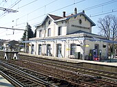
The commune has a train station on the Lyon – Genève railway line . It is also located on the trunk road and the largely parallel A 42 motorway from Lyon to Geneva . The route national 84 , which ran from Lyon to Geneva and was phased in 2006, runs through Meximieux, the oldest section of which is a one-way street in the Rue de Gèneve.
Personalities
- Claude Favre de Vaugelas (1585–1650), writer
Web links
- Official website of the municipality (French)

