
Murs-et-Gélignieux
| Murs-et-Gélignieux | ||
|---|---|---|
|
||
| region | Auvergne-Rhône-Alpes | |
| Department | Ain | |
| Arrondissement | Belley | |
| Canton | Belley | |
| Community association | Bugey Sud | |
| Coordinates | 45 ° 39 ′ N , 5 ° 40 ′ E | |
| height | 210-460 m | |
| surface | 6.46 km 2 | |
| Residents | 252 (January 1, 2017) | |
| Population density | 39 inhabitants / km 2 | |
| Post Code | 01300 | |
| INSEE code | 01268 | |

Murs-et-Gélignieux is a French commune on the right bank of the Rhone in the Ain department in the region of Auvergne Rhône-Alpes . The river is dammed in Murs-et-Gélignieux for the Brégnier-Cordon run- of - river power station . The Canal Brégnier absorbs most of the flowing water and directs it along the border to the northwestern Izieu and then through Brégnier-Cordon, the southwestern neighboring municipality. Murs-et-Gélignieux is also bordered by Peyrieu in the north, La Balme in the northeast and Champagneux in the southeast. A local elevation is the Mont Tournier .
Population development
| year | 1962 | 1968 | 1975 | 1982 | 1990 | 1999 | 2008 | 2016 |
|---|---|---|---|---|---|---|---|---|
| Residents | 150 | 127 | 131 | 121 | 188 | 204 | 238 | 255 |

Medieval house in the district of Murs

Castle of Murs

Grotte de la Bonne Femme, a monument historique
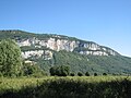
The Mont Tournier

"Saint-Maurice-de-Rotherens" is the name of a location on Mont Tournier. There you will find the menhir La Pierre Vire .
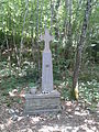
Field cross "La Dronière" in Saint-Maurice-de-Rotherens

Plan d'eau Cuchet: After the Canal Brégnier has left the natural Rhone, it touches an artificial lake.

Plan d'eau Cuchet with Mont Gela


