Artemare
| Artemare | ||
|---|---|---|

|
|
|
| region | Auvergne-Rhône-Alpes | |
| Department | Ain | |
| Arrondissement | Belley | |
| Canton | Hauteville-Lompnes | |
| Community association | Bugey Sud | |
| Coordinates | 45 ° 52 ' N , 5 ° 42' E | |
| height | 242-360 m | |
| surface | 3.75 km 2 | |
| Residents | 1,237 (January 1, 2017) | |
| Population density | 330 inhabitants / km 2 | |
| Post Code | 01510 | |
| INSEE code | 01022 | |
| Website | www.artemare.fr | |
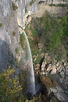
 View of Artemare |
||
Artemare is a French commune with 1,237 inhabitants (at January 1, 2017) in the department of Ain in the region Auvergne Rhône-Alpes . It belongs to the canton of Hauteville-Lompnes in the Arrondissement Belley and is a member of the Bugey Sud community association .
geography
Artemare is located at 258 m , about 13 kilometers north of the city of Belley (as the crow flies) and 51 km southeast of the prefecture of Bourg-en-Bresse . The village extends in the southeastern Bugey , in the valley of the Séran at the entrance to the valley of the Valromey , between the Jura mountain ranges of Planachat in the west and Grand Colombier in the east.
The area of the 3.75 km² large municipal area includes a section of the Bugey. The main part of the area is taken up by the approximately 2 km wide, flat valley plain of the Séran, which flows from northwest to southeast to the Rhone . To the west of the village, the Séran emerges from a rocky gorge and falls with an almost 70 m high waterfall ( Cascade de Cerveyrieu ) over a rock wall into the Artemare basin. In the area of Artemare, the Arvière (also called Groin) and the Dorfbach Yon flow into the Séran. In the south, the municipality reaches to the edge of the plateau of Ceyzérieu (up to 320 m ), in the west to the plateau de Fierloz ( 322 m ). To the north, the community area extends over the steep slope that leads to the Valromey. Artemare's highest point is reached on this slope at 360 m .
The hamlet of Cerveyrieu ( 255 m ) on the Séran near the waterfall belongs to Artemare . Neighboring municipalities of Artemare are Talissieu in the east, Ceyzérieu and Saint-Martin-de-Bavel in the south and Valromey-sur-Séran with Vieu in the west and in the north.
history
The municipality of Artemare was already settled during Roman times.
In the Middle Ages , Artemare formed its own rule, which was under the sovereignty of the Counts of Savoy. With the Treaty of Lyon , the village came to France in 1601.
Attractions
The parish church of Artemare was rebuilt around 1830. At the western entrance to the town is the Château de Machuraz with its round tower; it was built in the 16th century and restored in the 19th century. The Château d'Antioche rises above the village . In Cerveyrieu is the Maison des dîmes (tithe barn), which was built before 1572 and is flanked by a polygonal tower. One of the natural attractions is the 70 m high Cascade de Cerveyrieu, which is particularly impressive during floods.
population
| year | 1962 | 1968 | 1975 | 1982 | 1990 | 1999 | 2006 | 2011 |
| Residents | 743 | 838 | 810 | 914 | 961 | 970 | 1,074 | 1,140 |
With 1237 inhabitants (as of January 1, 2017), Artemare is one of the smaller communities in the Ain department. After the population had decreased significantly in the first half of the 20th century, the population has continued to grow since the early 1960s. The local residents of Artemare are called Artemarien (ne) s in French .
Economy and Infrastructure
Artemare was a predominantly agricultural village well into the 20th century . Viticulture still plays a role as a source of income for the locals on the slopes north of Artemare today . There are also some local small businesses. In the meantime, the village has also turned into a residential community. Many workers are commuters who go to work in the larger towns in the area.
The village is very well developed in terms of traffic. It is located on the departmental road D1504, which leads from Ambérieu-en-Bugey to Aix-les-Bains . Other road connections exist with Champagne-en-Valromey, Saint-Martin-de-Bavel and Belmont-Luthézieu. Artemare station on the Lyon – Genève railway line is no longer served.
Artemare has a state pre-school ( école maternelle ), a primary school ( école élémentaire ) and a comprehensive school ( collège ).
Web links
Individual evidence
- ^ André Buisson: Carte Archéologique de la Gaule - Ain 01 . Académie des Inscriptions et Belles-Lettres , 1990, ISBN 2-87754-010-3 , pp. 65 (French, limited preview in Google Book search).
- ↑ É. Philipon: Dictionnaire Topographique du Département de l'Ain . Imprimerie Nationale, 1911, p. 17th f . (French, online [PDF; accessed January 4, 2014]).
- ↑ French Statistics Institute ( www.insee.fr )
- ^ Artemare - notice communal. In: cassini.ehess.fr. Retrieved June 10, 2015 (French, INSEE population from 1968 ).

