Lagnieu
| Lagnieu | ||
|---|---|---|

|
|
|
| region | Auvergne-Rhône-Alpes | |
| Department | Ain | |
| Arrondissement | Belley | |
| Canton | Lagnieu | |
| Community association | Plaine de l'Ain | |
| Coordinates | 45 ° 54 ' N , 5 ° 21' E | |
| height | 192-643 m | |
| surface | 27.25 km 2 | |
| Residents | 7,143 (January 1, 2017) | |
| Population density | 262 inhabitants / km 2 | |
| Post Code | 01150 | |
| INSEE code | 01202 | |
 Town Hall ( Hôtel de ville ) |
||
Lagnieu ( Franco- Lagnioe ) is a French municipality with 7143 inhabitants (at January 1, 2017) in the Ain department in the region of Auvergne Rhône-Alpes . The inhabitants call themselves Lagnolans or Latinicois .
geography
The municipality of Lagnieu is located at the foot of the southwestern foothills of the Jura , near the striking Rhôneknie , about six kilometers south of Ambérieu-en-Bugey .
The districts of Charveyran, Chamoux, Posafol and Proulieu belong to Lagnieu .
Population development
| year | 1962 | 1968 | 1975 | 1982 | 1990 | 1999 | 2007 | 2017 |
| Residents | 3082 | 4162 | 5208 | 5594 | 5686 | 5882 | 6697 | 7143 |
Attractions
The Château de Montferrand, built in 1471, was divided into parcels during the French Revolution. Today the towers are missing, parts of the ensemble such as chimneys, window shutters (17th century) and wall paintings are still preserved. The remains of the castle are designated as a monument historique .
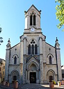
The Church of John the Baptist ( Église Saint-Jean-Baptiste ) was built between 1867 and 1870.
Web links
- Community presentation (French)
Individual evidence
- ^ Entry in the Base Mérimée of the Ministry of Culture. Retrieved January 3, 2012 (French).


