Corlier
| Corlier | ||
|---|---|---|

|
|
|
| region | Auvergne-Rhône-Alpes | |
| Department | Ain | |
| Arrondissement | Belley | |
| Canton | Hauteville-Lompnes | |
| Community association | Haut-Bugey agglomeration | |
| Coordinates | 46 ° 2 ′ N , 5 ° 30 ′ E | |
| height | 560-917 m | |
| surface | 5.45 km 2 | |
| Residents | 114 (January 1, 2017) | |
| Population density | 21 inhabitants / km 2 | |
| Post Code | 01110 | |
| INSEE code | 01121 | |
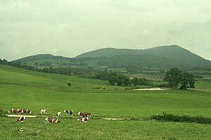
 View of Corlier and the Chaîne de l'Avocat mountain range from Aranc |
||
Corlier is a French municipality with 114 inhabitants (at January 1, 2017) in the department of Ain in the region Auvergne Rhône-Alpes . It belongs to the canton of Hauteville-Lompnes and the Arrondissement Belley . It is also a member of the Haut-Bugey Agglomération community association (until 2018: Plateau d'Hauteville ).
geography
Corlier is located at 775 m , about 13 kilometers northeast of the city of Ambérieu-en-Bugey and 29 kilometers southeast of the prefecture of Bourg-en-Bresse (beeline). The small farming village extends in central Bugey , in a hollow on the western edge of the Plateau d'Hauteville in the High Jura , at the southern foot of the Chaîne de l'Avocat ridge.
The area of the 5.45 km² large municipality covers a section of the southern French Jura. The area lies almost exclusively on the Jura high plateau. In the central part is the Corlier basin, which opens to the southeast towards the Aranc basin. This is drained on the one hand by the Grand Dard to the north to the Borrey (source brook des Oignin ), on the other hand by the mandorne to the south to the Albarine . To the west, the Mulde is delimited by a ridge on which the highest elevation of Corlier is reached at 917 m . To the north, the municipal area extends into a deeply cut valley at the foot of the Chaîne de l'Avocat , in which the Bief de la Fouge rises.
Neighboring municipalities of Corlier are Cerdon in the north, Izenave in the east, Aranc in the south and Boyeux-Saint-Jérôme in the west.
history
Since the 12th century Corlier formed its own small lordship, which initially belonged to the Lords of Rougemont and later to the Thoire-Villars and was under the sovereignty of the Counts of Savoy. With the Treaty of Lyon , Corlier came to France in 1601.
Attractions
The small village church of Saint-Agathe was built in the 13th century in Romanesque style and later changed several times. The ruins of the medieval manor house have been preserved.
population
| Population development | |
|---|---|
| year | Residents |
| 1962 | 89 |
| 1968 | 65 |
| 1975 | 69 |
| 1982 | 66 |
| 1990 | 76 |
| 1999 | 73 |
| 2006 | 109 |
| 2011 | 121 |
With 114 inhabitants (as of January 1, 2017) Corlier is one of the smallest communities in the Ain department. After the population had decreased significantly in the first half of the 20th century (197 people were still counted in 1901), the population has remained at a relatively constant level since the mid-1960s. The local residents of Corlier are called Corlieron (e) s in French .
Economy and Infrastructure
Corlier was a village dominated by agriculture , especially dairy and cattle breeding, well into the 20th century . Even today, the residents live mainly from their work in the first sector. Outside the primary sector there are few jobs in the village.
The village is located away from the major thoroughfares on a departmental road that leads from Saint-Jean-le-Vieux to Hauteville-Lompnes . Other road links exist with Saint-Martin-du-Frêne , Saint-Rambert-en-Bugey and Aranc. The closest connection to the A40 motorway is around 15 kilometers away.
Web links
Individual evidence
- ↑ É. Philipon: Dictionnaire Topographique du Département de l'Ain . Imprimerie Nationale, 1911, p. 131 (French, online [PDF; accessed January 4, 2014]).
- ^ Corlier - notice communal. In: cassini.ehess.fr. Retrieved June 11, 2015 (French, INSEE population from 1968 ).

