Oignin
| Oignin | ||
|
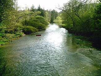
The river at Nurieux-Volognat |
||
| Data | ||
| Water code | FR : V25-0400 | |
| location | France , Auvergne-Rhône-Alpes region | |
| River system | Rhône | |
| Drain over | Ain → Rhône → Mediterranean | |
| source | in the municipality of Aranc 45 ° 59 ′ 30 ″ N , 5 ° 31 ′ 54 ″ E |
|
| Source height | approx. 890 m | |
| muzzle | in the municipality of Matafelon-Granges in the Ain Coordinates: 46 ° 17 ′ 32 " N , 5 ° 35 ′ 14" E 46 ° 17 ′ 32 " N , 5 ° 35 ′ 14" E |
|
| Mouth height | approx. 280 m | |
| Height difference | approx. 610 m | |
| Bottom slope | approx. 14 ‰ | |
| length | 44 km | |
| Right tributaries | Ange | |
| Reservoirs flowed through | Barrage des Trablettes , Barrage de Charmine | |
The Oignin (in the upper reaches under the names: Rouge Bief and Borrey ) is a river in France that runs in the Ain department in the Auvergne-Rhône-Alpes region . It has its source near Rougemont , in the municipality of Aranc, and generally drains northwards. At Maillat it reaches the A40 motorway and takes its definitive name Oignin here . In the further course it is dammed by the Barrage de Charmine and after a total of 44 kilometers it flows into the Ain at Coiselet , in the municipality of Matafelon-Granges as a left tributary .
Places on the river
- Rougemont, municipality of Aranc
- Izenave
- Vieu-d'Izenave
- Maillat
- Saint-Martin-du-Frêne
- Brion
- Géovreissiat
- Nurieux-Volognat
- Izernore
- Matafelon-Granges
- Coiselet, Matafelon-Granges municipality
Web links
Commons : Oignin - collection of images, videos and audio files
