
Nurieux-Volognat
| Nurieux-Volognat | ||
|---|---|---|
.svg)
|
|
|
| region | Auvergne-Rhône-Alpes | |
| Department | Ain | |
| Arrondissement | Nantua | |
| Canton | Pont d'Ain | |
| Community association | Haut-Bugey agglomeration | |
| Coordinates | 46 ° 11 ' N , 5 ° 32' E | |
| height | 448-840 m | |
| surface | 19.34 km 2 | |
| Residents | 1,028 (January 1, 2017) | |
| Population density | 53 inhabitants / km 2 | |
| Post Code | 01460 | |
| INSEE code | 01267 | |
| Website | www.nurieux-volognat.fr | |
 The town hall ( Mairie ) of Nurieux-Volognat |
||

Nurieux-Volognat is a French commune with 1,028 inhabitants (at January 1, 2017) in the department of Ain in the region Auvergne Rhône-Alpes . It belongs to the canton of Pont-d'Ain and the Arrondissement of Nantua .
geography
Nurieux-Volognat is located at 480 m , about 13 kilometers southwest of the city of Oyonnax and 23 kilometers east of the prefecture of Bourg-en-Bresse (beeline). The village extends in northern Bugey , on the southwestern edge of the basin of Izernore , in the Jura , at the eastern foot of the anticline of the Montagne de Berthiand.

The area of the 19.34 km² municipal area covers a section of the southern French Jura. The eastern part is taken up by the approximately 2 km wide, north-south oriented valley of Izernore, which forms a syncline in the Folded Jura and is drained north through the Oignin to the Ain . The valley basin is on average at 480 m. The basin rises gradually towards the south. To the west, the valley basin is flanked by the anticline of the Montagne de Berthiand , on which the highest point of Nurieux-Volognat is reached at 836 m . This mountain range is subdivided by various short erosion valleys from side streams of the Oignin. The western border runs above the steep drop to the valley of the Ain.
The municipality of Nurieux-Volognat consists of different villages, hamlets and farm groups, namely:
- Nurieux ( 480 m ) in the Izernore basin at the foot of the Montagne de Berthiand
- Volognat ( 520 m ) at the eastern foot of the Montagne de Berthiand at the narrow entrance into a side valley
- Mornay ( 620 m ) on a ledge high above the Izernore basin
- Crépiat ( 645 m ) on a plateau south of Mont Griset
- Vers ( 750 m ) in a hollow on the Montagne de Berthiand
Neighboring municipalities of Nurieux-Volognat are Sonthonnax-la-Montagne in the north, Izernore, Béard-Géovreissiat and Brion in the east, Saint-Martin-du-Frêne and Peyriat in the south and Leyssard in the west.
history
The municipality was already settled during the Bronze Age and the Roman Age. A Cluniac priory existed in Mornay since the Middle Ages . Mornay formed a rule on which Volognat was dependent. The Thoire-Villars initially had sovereignty over the area, and from 1402 the Counts of Savoy . With the Treaty of Lyon , Mornay and Volognat came to France in 1601. With the construction of the railway line from Bourg-en-Bresse via Nantua to Bellegarde-sur-Valserine , the hamlet of Nurieux (part of the municipality of Mornay) received a train station. Because of its convenient location, Nurieux developed much faster than the farming village of Mornay and became the focus of the community's settlement. In 1973 the two municipalities of Mornay and Volognat merged, with the new municipality being named Nurieux-Volognat .
Attractions
The Romanesque church of Mornay originally dates from the 11th century, was later redesigned several times and has wall paintings from the 15th century. The church of Volognat dates from the 19th century.
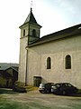
Volognat village church
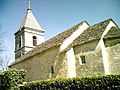
Mornay Chapel

Nurieux train station


population
| Population development | |
|---|---|
| year | Residents |
| 1962 | 466 |
| 1968 | 500 |
| 1975 | 567 |
| 1982 | 656 |
| 1990 | 856 |
| 1999 | 952 |
| 2006 | 1,045 |
| 2011 | 1,044 |
With 1028 inhabitants (January 1, 2017) Nurieux-Volognat is one of the smaller municipalities in the Ain department. Since the beginning of the 1960s, there has been a significant increase in population, combined with a doubling of the population.
Economy and Infrastructure
Nurieux-Volognat was a predominantly agricultural village well into the 20th century . There are also some small and medium-sized businesses today. Nurieux is the location of a plastics processing company and an electricity company. In the meantime, the village has also turned into a residential community. Many workers are therefore commuters who work in the larger towns in the area.
The place is well developed in terms of traffic. It is located on the D979 departmental road that leads from Nantua over the Col de Berthiand to Bourg-en-Bresse. Other road connections exist with Izernore, Sonthonnax-la-Montagne and Peyriat. The closest connection to the A404 motorway (Saint-Martin-du-Frêne - Oyonnax) is around 4 km away.
Nurieux has a train station on the Bourg-en-Bresse – Bellegarde line . A pair of trains à grande vitesse (TGV) on the Geneva - Paris Gare de Lyon line stop here every day . TER trains from Bourg-en-Bresse to Oyonnax also stop in Nurieux .
In Nurieux-Volognat there is a state école primaire (elementary school with an integrated preschool ).
Web links
Individual evidence
- ↑ a b Nurieux-Volognat - notice communale. In: cassini.ehess.fr. Retrieved on June 14, 2015 (French, INSEE population from 1968 ).
- ↑ French Statistics Institute ( www.insee.fr )