Nantua
| Nantua | ||
|---|---|---|

|
|
|
| region | Auvergne-Rhône-Alpes | |
| Department | Ain | |
| Arrondissement | Nantua | |
| Canton | Nantua | |
| Community association | Haut-Bugey agglomeration | |
| Coordinates | 46 ° 9 ' N , 5 ° 36' E | |
| height | 427-1,127 m | |
| surface | 12.79 km 2 | |
| Residents | 3,446 (January 1, 2017) | |
| Population density | 269 inhabitants / km 2 | |
| Post Code | 01130 | |
| INSEE code | 01269 | |
| Website | www.nantua.fr | |
 Nantua |
||
Nantua is a French municipality with 3446 inhabitants (at January 1, 2017) in the Ain department in the region of Auvergne Rhône-Alpes . It is a sub-prefecture of the Nantua arrondissement .
geography
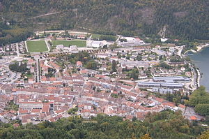
Nantua is located at 480 m , about 30 kilometers east of Bourg-en-Bresse and 45 kilometers west of Geneva (as the crow flies). The small town extends in the Haut- Bugey , in the Jura , in the deeply incised Cluse de Nantua , a transverse valley through the Jura chains ( Klus ), on the brook Doye (tributary of the Lac de Nantua ).
The area of the 12.79 km² municipal area includes a section of the southern French Jura. The central part of the area is occupied by the Cluse de Nantua, which is oriented towards the southwest-northeast. It forms a transverse valley that stretches from Nantua to the Valserine catchment area through the chains of the Upper Jura. The valley floor near Nantua is around 800 m wide and rises towards the northeast to the Lac de Sylans . After a landslide in the 16th century, this lake was dammed and has an underground drain. Its water reappears in the Source de la Doye near Les Neyrolles.
The Cluse de Nantua is flanked on both sides by up to 500 m high steep slopes, which are criss-crossed by striking rock walls. North of the transverse valley are Mont Cornet and Mont Burdet , and south of them Mont Pommier ( 1053 m ). To the south, the municipality extends over the forest tops of the Forêt de Combe Noire to the height of Les Monts d'Ain , at 1127 m the highest point in the Nantua area.
Neighboring municipalities to Nantua are Apremont and Charix in the northeast, Les Neyrolles in the east, Saint-Martin-du-Frêne in the southwest, Port in the west and Montréal-la-Cluse in the northwest.
history
Emperor Charles the Bald was buried in Nantua in October 877, but was later reburied in the cathedral of Saint-Denis .
During the Second World War , the Resistance in and around Nantua was comparatively strong. Therefore, the German occupation forces raided the place with several raids. During the raid on December 14, 1943 (“rafle de Nantua”), 150 men between the ages of 18 and 40 were arrested and most of them were deported to the Buchenwald concentration camp , including the local vicar , Gabriel Gay (1911–1945).
Population development
| year | 1946 | 1954 | 1962 | 1968 | 1990 | 1999 | 2006 | 2011 |
| Residents | 3,265 | 3,560 | 3,440 | 3,572 | 3,602 | 3,922 | 3,693 | 3,651 |
Architectural monuments
See: List of Monuments historiques in Nantua
Town twinning
Culinary
A specialty is the crayfish sauce Sauce Nantua , named after the city , which is usually served with fish dumplings.
Sons and daughters of the town
- Noël del Bello (* 1942), car racing driver and racing team owner
- Robert Lestienne (1892–1944), racing car driver
- François Lecot (1878–1959), racing car driver
Footnotes
- ^ P. Armand, M. Givre: Un Témoin du Christ parmi les déportés. L'abbé Gabriel Gay, vicaire de Nantua . Éditions du Témoignage chrétien, Paris 1948.
Web links
- Community presentation (French)
