Champfromier
| Champfromier | ||
|---|---|---|
|
|
||
| region | Auvergne-Rhône-Alpes | |
| Department | Ain | |
| Arrondissement | Nantua | |
| Canton | Bellegarde-sur-Valserine | |
| Community association | Pays Bellegardien | |
| Coordinates | 46 ° 12 ' N , 5 ° 49' E | |
| height | 480-1,540 m | |
| surface | 32.40 km 2 | |
| Residents | 729 (January 1, 2017) | |
| Population density | 23 inhabitants / km 2 | |
| Post Code | 01410 | |
| INSEE code | 01081 | |
| Website | champfromier.free.fr | |
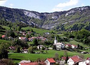
 View of Champfromier |
||
Champfromier is a French municipality with 729 inhabitants (at January 1, 2017) in the department of Ain in the region Auvergne Rhône-Alpes . It belongs to the canton of Bellegarde-sur-Valserine in the Arrondissement of Nantua and is a member of the Pays Bellegardien municipal association .
geography
Champfromier is located at 646 m , about ten kilometers north of the town of Bellegarde-sur-Valserine (as the crow flies). The farming village extends in the French Jura in the open basin of a side valley of the Valserine , at the southern foot of the Crêt du Mont .
The area of the 32.40 km² large municipal area includes a section of the Upper Jura. The southeastern border runs along the Valserine, which flows from northeast to southwest in an erosion valley cut around 100 m into the surrounding area . The valley is accompanied on both sides by steep slopes, some of which are criss-crossed with ledges. The municipality extends from the river to the north and includes the wide basin of Champfromier, which opens to the south. This is bordered in the west by the Cruchon ( 1143 m ), in the north by the Crêt du Mont ( 1380 m ) and in the east by the Bois des Ecretats ( 1080 m ), whereby the heights have steep slopes with sometimes striking rock faces, including the Cirque des Avalanches .
The northern part of the municipality is occupied by a predominantly wooded high plateau ( Forêt de Champfromier , an average of 1200 m ), which adjoins the Crêt du Mont and culminates in the Haute Crête ( 1415 m ). Beyond this plateau, the municipal area extends into the headwaters of the Semine and up to the summit of the Crêt de Chalam , on which the highest elevation of Champfromier is reached at 1545 m . The municipality is part of the Haut-Jura Regional Nature Park (French: Parc Naturel Régional du Haut-Jura ).
In addition to the actual village, Champfromier also includes various hamlets and farms, namely:
- Communal ( 770 m ) on a ledge west of the village
- Le Bordaz ( 720 m ) in the basin of Champfromier above the village
- Monnetier ( 710 m ) in the Champfromier basin at the southern foot of the Crêt du Mont
Neighboring municipalities of Champfromier are La Pesse in the north, Chézery-Forens in the east, Montanges in the south and Saint-Germain-de-Joux , Giron and Belleydoux in the west.
history
The discovery of a Burgundian cemetery near the village church indicates a 5th century settlement. Champfromier was first mentioned in documents in 930, when Count Albitius of Geneva left the area to the monastery of Nantua . Over time, the spelling changed from Chanfromer (1344) to Ecclesia Campi Fromerii (1399) to Chanfromier (1734). The etymology is not clear. The place name probably goes back to Campus Fromarii and means field of Frumaharius (Burgundian personal name).
Attractions
The parish church, which originally dates back to a building from the 10th century, was rebuilt from 1825 to 1827.
See also: List of the Monuments historiques in Champfromier
population
| Population development | |
|---|---|
| year | Residents |
| 1962 | 517 |
| 1968 | 428 |
| 1975 | 326 |
| 1982 | 332 |
| 1990 | 440 |
| 1999 | 593 |
| 2006 | 606 |
| 2011 | 676 |
With 729 inhabitants (as of January 1, 2017), Champfromier is one of the small communities in the Ain department. After the population had decreased significantly in the first half of the 20th century, the population has continued to grow steadily since the early 1980s. Since then the population has almost doubled. The local residents of Champfromier are called Champfromérand (e) s in French .
Economy and Infrastructure
Until well into the 20th century, Champfromier was mainly a village characterized by agriculture and forestry. Today there are some small and medium-sized businesses. The Société Coutier (manufacture of car accessories) and a sawmill are important. Many workers are also commuters who work in the larger towns in the area and mainly in Bellegarde-sur-Valserine.
The village is located off the major thoroughfares on the D14 department road, which leads from Tacon (on the main road D1084 ) through the Valserine Valley to Chézery-Forens. Another road connection is with Giron. The closest connection to the A40 motorway is around 16 kilometers away.
In Champfromier there is a state école primaire (elementary school with an integrated preschool ).
Web links
- Official website of the municipality of Champfromier (French)
- Aerial view of the commune of Champfromier
Individual evidence
- ^ André Buisson: Carte Archéologique de la Gaule - Ain 01 . Académie des Inscriptions et Belles-Lettres , 1990, ISBN 2-87754-010-3 , pp. 38 (French, limited preview in Google Book search).
- ^ Noms de lieux de Suisse Romande, Savoie et environs - lettre "Ch". In: henrysuter.ch. Retrieved November 15, 2011 (French).
- ↑ Champfromier - notice communal. In: cassini.ehess.fr. Retrieved on June 3, 2015 (French, INSEE population from 1968 ).
