
Upper Jura Regional Nature Park

_-_Entr%C3%A9e_D984E.JPG)


_en_ao%C3%BBt_2011.jpg)
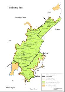
The Haut-Jura Regional Nature Park ( French: Parc naturel régional du Haut-Jura ) is located in the southwestern section of the Jura Mountains in the French regions of Bourgogne-Franche-Comté and Auvergne-Rhône-Alpes and borders in the east partly on Swiss national territory and on the the Parc naturel regional Jura vaudois located there
- The north-eastern part of the nature park is located in the Doubs department and roughly borders the upper reaches of the Doubs river .
- The middle part lies in the Jura department and includes the area from the High Jura (French Haut-Jura ) with the highest elevations in the park in the east to the valley of the Ain in the west.
- The southern part is in the Ain department in the neighboring Rhône-Alpes region and extends as far as the Rhône Valley in the south .
Park management
The nature park was founded on April 21, 1986 and today covers an area of around 178,000 hectares. The park administration is based in Lajoux ( 46 ° 22 ′ 30 ″ N , 5 ° 58 ′ 21 ″ E, ), where the "Maison du Parc" is located is located. 118 communities with a catchment area of around 82,000 inhabitants form the park. In addition, the municipalities of Bellegarde-sur-Valserine , Champagnole , Divonne-les-Bains , Ferney-Voltaire , Gex , Pontarlier and Oyonnax are associated with the park as access points.
Larger places in the park
landscape
From a geological point of view, the nature park is located in the Chain Jura , which is characterized by mostly parallel limestone mountain chains that run from northeast to southwest . Here are also the highest peaks, the Crêt de la Neige (1720 m), the Reculet (1719 m) and the Grand Crêt (1702 m). The rivers running between the chains drain in the northern part to the northeast ( Doubs and Orbe ) and in the southern part to the southwest ( Valserine , Bienne , Ain ). To the east, the terrain slopes down to Lake Geneva , from the Col de la Faucille you have a wonderful view of the Pays de Gex and Geneva , with the panorama of the Alps in the background. To the west the terrain loses a little height, the highest peaks are only around 1000 meters high here. The bottom of the valleys, which has often been waterproofed by a layer of marl , forms small basin landscapes and allows the creation of mountain lakes ( Lac de l'Abbaye , Lac des Rousses , Lac de Remoray ) and peat bogs .
Flora and fauna
The park represents the whole range of vegetation , from the alluvial forests of alders , willows and ash trees on the lower reaches of the Bienne to the mountain pines on the Crêt de la Neige. While the water quickly seeps into the subsoil in the porous limestone, the valleys are enlivened by rivers that are rich in water. The dominant spruce forest is the habitat for deer , wild boar , badger and martens , but the lynx is also native here, even if it is very shy and rarely shows up. The high massifs protect the ring owl , the black woodpecker , but also the capercaillie and the barnacle owl .
Economy and tourism
But the nature park is also an inhabited territory, the population of which makes a living from a variety of products. The herds of Montbéliard cattle supply the entire region with milk , which is also processed into the AOC cheeses Morbier and Bleu de Gex . The craftsmen keep the tradition of woodturning wooden or horn materials , the gemstone , the watch-making , the production of pipes , toys and fashion items, such as glasses or buttons . Of course, tourism also plays a major role, which can not only be operated here in summer, but also offers an attractive environment for cross-country skiers and snowshoe hikers in winter . But lovers of alpine skiing can also satisfy their passion on the slopes of Les Rousses , Mijoux , Crozet , Lélex or in Menthières , municipality of Chézery-Forens .
See also
Web links
- Website of the nature park (French)