Reculet
| Reculet | ||
|---|---|---|
|
Summit cross of the Reculet |
||
| height | 1717 m | |
| location | Ain department , France | |
| Mountains | law | |
| Coordinates | 46 ° 15 '25 " N , 5 ° 55' 48" E | |
|
|
||
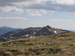
At 1717 m, the Reculet is the second highest mountain peak in the entire Jura . It belongs to the Haute Chaîne , the westernmost and highest chain of the French Jura, and is located in the Pays de Gex (Département Ain ), around 18 kilometers west-northwest of the city of Geneva . The mountain name has the meaning of secluded, remote place .
The Reculet is bounded in the east by the plain of the Pays de Gex and in the west by the valley of the Valserine . The ridge of the Reculet slopes steeply in these two directions. It rises directly from the plain of the Pays de Gex without a foothill zone and towers over the Geneva basin by around 1300 m. To the northeast, the Jura ridge leads over the saddle from Sur Thoiry (1640 m) directly to the Crêt de la Neige , to the south-west a long mountain ridge extends to the Grand Crêt d'Eau . The official height of the Reculet is given as 1717 m , which results from rounding off the actually measured height of 1717.4 m . This means that the Reculet was only 20 cm lower than the neighboring Crêt de la Neige ( 1717.6 m , today there is a height difference of around 3 m) before the remeasurement in 2003 . It used to be assumed that the Reculet was the highest mountain in the Jura.
In structural and geological terms, the Reculet forms an anticline of the Jura folds , whereby the rock layers were pushed onto the sediments further west at the time of the Jura folding in the late Miocene and Pliocene . The anticline is around 5 km wide at the root and is oriented in the direction south-south-west-north-north-east in accordance with the strike direction of the Jura chains in this mountain section. The rock material of the Reculet comes from marine sediments of the Upper Jurassic Period (in the ridge area, the dolomitic limestone of Portlandia , the limestone banks of the Kimmeridgia and Sequania occur) and the Cretaceous period (mainly at the foot of the slope). On the Roche Franche , a steep rockfall southwest of the Reculet in the catchment area of the Valserine valley, the relief-forming rock layers and the fold structure of the Haute Chaîne are well exposed.
Due to the limestone , various karst phenomena could develop on the ridge of the Reculet . There are numerous sinkholes and cart fields here , the rainwater seeps into the porous subsoil and mostly only reappears in karst springs at the foot of the Jura range. That is why the slopes of the Haute Chaîne show very few surface running waters.
The summit area of Reculet is grassy and shows subalpine vegetation. Mountain pastures predominate above about 1400 m, below a coniferous forest zone, which in turn is replaced by deciduous forest below about 900 m. The Reculet is a beautiful panoramic mountain of the Hochjuras; On a clear day there is an impressive view over the Geneva basin to the Savoy Alps with Mont Blanc . The Reculet is part of the Parc Naturel Régional du Haut-Jura and the Haute Chaîne du Jura nature reserve .
Web links
- Le Reculet on GeoFinder.ch


