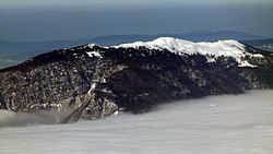
Grand Crêt d'Eau
| Grand Crêt d'Eau | ||
|---|---|---|
|
Grand Crêt d'Eau |
||
| height | 1621 m | |
| location | Ain , France | |
| Mountains | law | |
| Coordinates | 46 ° 9 '2 " N , 5 ° 51' 50" E | |
|
|
||
The Grand Crêt d'Eau is a mountain range with several neighboring mountain peaks in the Ain department , which forms the southern end of the French Jura . It is located in the communes of Bellegarde-sur-Valserine , Chézery-Forens , Collonges , Confort , Farges , Lancrans and Léaz . The highest peak reaches 1621 m.
Below the Grand Crêt d'Eau in the southwest is the town of Bellegarde-sur-Valserine at the end of the Valserine valley , in the east the Pays de Gex and the Geneva Basin and in the south the Défilé de l'Écluse , a breakthrough valley of the Rhone , through which the railway line runs from Geneva to Lyon .
The following peaks belong to the mountain range:
- Crêt de la Goutte (1621 m)
- Crêt du Milieu (1597 m)
- Crêt du Miroir (1584 m)
- Crêt de l'Éguillon (1546 m)
- Crêt des Frasses (1536 m).
Web links
Commons : Grand Crêt d'Eau - Collection of images, videos and audio files


