Défilé de l'Écluse
| Défilé de l'Écluse | ||
|---|---|---|
|
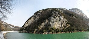
Bend in the Défilé de l'Écluse with a view of the Montagne de Vuache |
||
| location | France | |
| Waters | Rhone | |
| Mountains | Jura / Montagne de Vuache | |
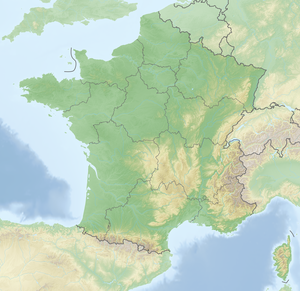
| Geographical location | 46 ° 7 '12 " N , 5 ° 53' 38" E | |
|
|
||
| Type | Klus | |
| length | 2 km | |
The Défilé de l'Écluse is a transverse valley ( Klus ) in which the Rhone breaks through the first and highest mountain range ( anticline ) of the French Jura Mountains . It lies between the Franco-Swiss border and the town of Bellegarde-sur-Valserine on the border between the departments of Ain and Haute-Savoie . For centuries, the very narrow opening formed the only connection between the Pays de Gex and the rest of France and was secured by Fort l'Écluse , which was built into the steep slope at great expense, but has now lost its military function.
Topography and landscape
The Défilé de l'Écluse forms the end of the Geneva basin through which the Rhone flows. The river reaches the Jura in an east-west direction at a height of 345 m over a one to two kilometer wide valley with swamps and alluvial islands ( Site de l'Étournel ), which is about 100 m deep into the hilly landscape . In the gorge, the massif of the 1621 m high Grand Crêt d'Eau rises to the right , part of the Haute Chaîne du Jura . It forms a steep flank that rises evenly from the waterline to a land ledge at 1124 m . The Montagne de Vuache rises to the left with a similarly steep slope up to the Oratoire Sainte-Victoire at 934 m . Within the gorge, the river bends south and circles the base of the Vuache. Behind the breakthrough, the valley cut remains narrow with flanks that are about 150 m high and partially crisscrossed by rock walls.
At the entrance to the Défilé de l'Écluse, the structure of the river bed changes from a flat alluvial soil to a karst formation that is hollowed out into an ever narrower and deeper canyon downstream. The side walls came so close at Gresin that a small arch bridge was enough to cross them, and in a chasm near Bellegarde there was an infiltration section ( French pertes du Rhône ) with a depth of up to 60 m. Today, these structures are all deep under the water surface, as the Génissiat dam dams the Rhone over a length of 23 km and includes the Défilé de l'Écluse. The municipalities at the Rhone Gorge are Collonges , Chevrier , Clarafond-Arcine and Léaz .
The topography of the Défilé de l'Écluse has an impact on the climate in the Geneva Basin and, especially in the winter months, favors inversion weather conditions , during which high fog and cold air masses are trapped in the mountain ranges around Geneva for days or weeks .
The slopes of the Grand Crêt d'Eau and the Montagne de Vuache are largely forested in the area of the Défilé de l'Écluse. The Grand Crêt d'Eau belongs to the nature reserves Reserve naturelle nationale de la Haute chaîne du Jura and the Regional Nature Park Haut-Jura .
geology
The Rhone existed as a larger flowing body of water before the Jura mountains unfolded and, with its hydropower and suspended matter, eroded the limestone just as quickly as it was unfolding. The rock layers exposed on the two valley flanks fit together exactly. The creation of the Grand Crêt d'Eau is the result of a complex process in which two different folds overlap and further distortions play a role. Here the several tens of kilometers long and two to five kilometers deep folds of the Vuache unite with the anticlines of the Jura. In the Vuache, the rock strata is almost vertical, and the Rhone cuts through a series of strata (seen in the direction of flow) from the Barremium in the Lower Cretaceous to roughly the Kimmeridgian in the Upper Jurassic . In front of and behind the Vuache there is a molasse basin that was shaped by the Ice Age Rhone glacier.
Traffic routes
Several important traffic routes run through the Défilé de l'Écluse. These include the Lyon – Geneva and Léaz – Saint-Gingolph lines . The latter branches off the main Lyon-Geneva line at Longeray and changes at the bottleneck over the Viaduc de Longeray to the Savoyard side of the Rhone. The main road D1206 (former N84 and N206 ) from the Pays de Gex to Bellegarde runs on the right bank of the Rhones in a tunnel parallel to Fort l'Écluse. On the opposite side at about the same height, a road connects the villages on the northeast side of the Montagne de Vuache with those on the southwest side. As a road bridge, the Pont Carnot crosses the river when it enters the narrow section, it connects Collonges with Vulbens and Saint-Julien-en-Genevois .
history
Caesar already knew the Rhone breakthrough in his De bello Gallico as a strategic bottleneck that would cause problems for the Helvetians:
"Erant omnino itinera duo, quibus itineribus domo exire possent: unum per Sequanos, angustum et difficile, inter montem Iuram et flumen Rhodanum, vix qua singuli carri ducerentur, mons autem altissimus impendebat, ut facile perpauci prohibere possent;"
“There were only two ways they could leave home: one through the Sequaner area, narrow and difficult, between the Jura mountains and the Rhône, where individual cars could hardly drive but a very high mountain loomed up, so that very few could easily block it. "
In the 12th century there was a small settlement in the narrow passage that belonged to the Abbey of Saint-Claude and was under the sovereignty of the Counts of Geneva . The abbey passed the settlement on to the Lords of Gex in 1225 , who levied a road toll and built a permanent house , which was mentioned in a document towards the end of the 13th century ( Castrum de Clusa 1277 and Clusa de Gayo 1286). A few years later they sold it to the Counts of Savoy , who held it intermittently until the Treaty of Lyon (1601). From then until the annexation of Savoy to France in 1860, the right bank with the ever more developed Fort l'Écluse belonged to the Kingdom of France, while the left bank was part of Savoy. It was only with the solution of the Dappental question in 1862 and the construction of the Pont Carnot from 1865–1874 that road connections between the Pays de Gex and the French Kingdom were created that did not depend on the Défilé de l'Écluse.
On January 2nd and 3rd, 1883, a landslide occurred in the right flank of the valley about 100 m upstream from Fort l'Écluse. He tore up part of the railway line and jammed the Rhone for a few hours. Investigations revealed that an underground karst spring from the Grand Crêt d'Eau massif had destabilized the slope made up of ice-age sediments. A relief borehole from the side has since drained the karst spring into a harmless bank area.
Web links
- Le site classé du défilé de l'Écluse , brochure from the direction régionale de l'environnement Rhône-Alpes (French, PDF, 820 kB).
Individual evidence
- ↑ J. Charollais et al .: Présentation d'une nouvelle carte géologique du Vuache et du Mont de Musièges . In: Arch.Sci . tape 66 , 2013, p. 1–64 (French, online [PDF]).
- ↑ De Bello Gallico: Liber I - Chapter VI on Wikibooks
- ↑ É. Philipon: Dictionnaire Topographique du Département de l'Ain . Imprimerie Nationale, 1911, p. 180 (French, online [PDF; accessed January 4, 2014]).
- ↑ Le Jura glisse dans le Rhône, Genève a failli être engloutie. In: Tribune de Genève. Retrieved February 3, 2016 (French).


