
Collonges (Ain)
| Collonges | ||
|---|---|---|
.svg)
|
|
|
| region | Auvergne-Rhône-Alpes | |
| Department | Ain | |
| Arrondissement | Gex | |
| Canton | Thoiry | |
| Community association | Pays de Gex | |
| Coordinates | 46 ° 8 ' N , 5 ° 54' E | |
| height | 329-1,621 m | |
| surface | 16.25 km 2 | |
| Residents | 2,219 (January 1, 2017) | |
| Population density | 137 inhabitants / km 2 | |
| Post Code | 01550 | |
| INSEE code | 01109 | |

Collonges is a French commune with 2,219 inhabitants (at January 1, 2017) in the department of Ain in the region Auvergne Rhône-Alpes . It belongs to the canton of Thoiry in the Gex arrondissement and is a member of the Pays de Gex municipal association .
geography
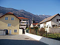
Collonges is located at 495 m , about 20 kilometers west-southwest of the city of Geneva and 53 km east of the prefecture of Bourg-en-Bresse (as the crow flies). The former farming village extends in the southwest of the Pays de Gex in a promising elevated position at the foot of the Jura below the Grand Crêt d'Eau , on the western edge of the Geneva Basin at the eastern entrance to the Défilé de l'Écluse .
The area of the 16.25 km² municipal area covers a section of the Pays de Gex. The area is divided into two naturally very different parts. The eastern part is occupied by the fertile plain at the foot of the Jura. This plateau, a molasse basin that was shaped by the Ice Age Rhone glacier , is drained by the Annaz to the Rhone . The plateau gradually rises towards the Jura. The southern border runs along the Rhône, which is dammed up in front of the upper entrance in the Défilé de l'Écluse to form a long flat lake with alluvial islands.
To the west, the community area extends over the steep, densely wooded slope to the ridge of the foremost Jura chain. The border forms the crest of the Grand Crêt d'Eau, on which the highest elevation of Collonges is reached at 1621 m . There are extensive mountain pastures above around 1400 m . Towards the south the ridge drops steeply to the Rhône Gorge Valley (Défilé de l'Écluse). The municipality is part of the Upper Jura Regional Nature Park (French: Parc naturel régional du Haut-Jura ).
In addition to the original location, Collonges also includes various hamlets and farms, including:
- Ecorans ( 525 m ) at the foot of the Jura north of the village
- Pierre d'en Bas ( 480 m ) on the plateau north of the Rhône valley
- Pierre d'en Haut ( 497 m ) on the plateau north of the Rhône valley
Collonges' neighboring municipalities are Farges in the north, Pougny in the east, Vulbens and Chevrier in the south and Léaz , Lancrans and Confort in the west.
history
Collonges was first mentioned in a document in the 10th century. Later, the spellings Collunges (1441), Colonges (1460) and Collonge (in the 18th century) appeared. The place name goes back to the old French word collonge (colony; land that belongs to a settler).
From the 12th century Collonges formed a parish that was dependent on the Ainay Monastery. In the Middle Ages , the area of Collonges was divided into different lords. In the 14th century the village came under the sovereignty of the Counts of Savoy . Collonges then shared the eventful history of the Pays de Gex , with which it finally came to France after the conclusion of the Treaty of Lyon in 1601.
From 1793 to 2015 the municipality was the main town (French: chef-lieu ) of the canton of Collonges .
Attractions
The village church of Saint-Théodule was built in the 19th century. Only a few ruins remain of the former Ecorans castle (13th century). Parts of the Château Livron as well as a manorial seat in Collonges have been preserved. In the center there are various old farmhouses from the 18th and 19th centuries in the traditional style of the Pays de Gex. The nearby Défilé de l'Écluse gorge with its fortifications is also one of the sights.

Saint-Théodule church
View over the church to the Jura


population
| Population development | |
|---|---|
| year | Residents |
| 1962 | 879 |
| 1968 | 901 |
| 1975 | 966 |
| 1982 | 926 |
| 1990 | 1000 |
| 1999 | 1106 |
| 2006 | 1221 |
| 2011 | 1979 |
With 2219 inhabitants (as of January 1, 2017), Collonges is one of the medium-sized communities in the Ain department. Since the mid-1960s, population growth has been recorded, the acceleration of which took place with some delay compared to the other municipalities of the Pays de Gex. The local people of Collonges are called Collongeois (es) in French .
Economy and Infrastructure
Until well into the 20th century, Collonges was a predominantly agricultural village. Today there are some local small businesses. In the meantime, the village has also turned into a residential community. Many workers are commuters who work in the larger towns of the Pays de Gex or as cross-border commuters in the agglomeration of Geneva.
The place is well developed in terms of traffic. It is on the main road D984, which leads from Collonges along the foot of the Jura to Saint-Genis-Pouilly . Through the construction of a bypass, the village center was relieved of through traffic. Further national road connections exist with Bellegarde-sur-Valserine and Saint-Julien-en-Genevois . The closest connection to the A40 motorway is around 15 kilometers away.
Collonges owned a train station on the Lyon – Genève railway line . This is where the Collonges – Divonne-les-Bains railway branches off and is now closed.
There is a state école primaire (elementary school with an integrated preschool ) in the village .
Web links
Individual evidence
- ^ A b Collonges - notice communale. In: cassini.ehess.fr. Retrieved June 21, 2015 (French, INSEE population from 1968 ).
- ↑ French Statistics Institute ( www.insee.fr )