Segny
| Segny | ||
|---|---|---|

|
|
|
| region | Auvergne-Rhône-Alpes | |
| Department | Ain | |
| Arrondissement | Gex | |
| Canton | Thoiry | |
| Community association | Pays de Gex | |
| Coordinates | 46 ° 18 ' N , 6 ° 4' E | |
| height | 467-519 m | |
| surface | 3.24 km 2 | |
| Residents | 2,062 (January 1, 2017) | |
| Population density | 636 inhabitants / km 2 | |
| Post Code | 01170 | |
| INSEE code | 01399 | |
| Website | www.segny.fr | |
Ségny is a French commune in the Ain department in the region of Auvergne Rhône-Alpes .
geography
Ségny is located at 487 m , four kilometers south of Gex and about twelve kilometers north-northwest of the city of Geneva (as the crow flies). The former farming village extends in the Pays de Gex , on a slightly south-sloping plateau at the foot of the Jura , in the northern area of the Geneva basin, east of the Journans stream .
The area of the 3.24 km² municipal area covers a section of the Pays de Gex. The area with only very weak relief forms a plateau that rises gently towards the Jura. To the west, the community area extends into the valley of the Journans (in the Allondon catchment area ) and its side stream Varfeuille . This flat flood plain is covered by an extensive forest area. To the west of this is the Suraz hill , on which the highest point of Ségny is reached at 520 m . In the south, the parish ban extends to the course of the Lion , which also feeds its water to the Journans.
Neighboring communities of Ségny are Cessy in the north, Versonnex and Ornex in the east, Prévessin-Moëns in the south and Chevry and Échenevex in the west.
history
Ségny was first mentioned in a document in 1397 under the name Signier . Over time, the spelling changed via Segniez (1444), Signiez (1528), Signyez (1573), Segni (1589) and Cegny to today's place name Ségny, which has been documented in writing since 1691. The name Signy has survived from 1744 . The place name goes back to the Gallo-Roman surname Signius and means something like Signius' estate (Signiacum). Since the 14th century, the village was under the sovereignty of the Counts of Savoy . Then Ségny shared the eventful history of the Pays de Gex , with which it finally came to France after the conclusion of the Treaty of Lyon in 1601.
Attractions
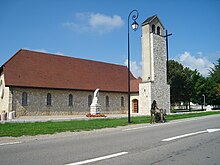
The Notre-Dame-de-la-Route-Blanche church was built in 1952.
Population development
| year | 1962 | 1968 | 1975 | 1982 | 1990 | 1999 | 2007 |
| Residents | 279 | 449 | 783 | 1002 | 1211 | 1348 | 1536 |
With 2062 inhabitants (as of January 1, 2017), Ségny is one of the smaller communities in the Ain department. The population has grown significantly since the mid-1960s. Particularly strong growth rates were registered during the 1970s. Numerous new single-family houses were built outside the old town center.
Economy and Infrastructure
Ségny was a predominantly agricultural village well into the 20th century . Today there are some small and medium-sized businesses. In the meantime the village has turned into a residential community. Many workers are commuters who work in the larger towns of the Pays de Gex or as cross-border commuters in the agglomeration of Geneva.
The place is well developed in terms of traffic. It is located on the main road N5, which leads from Geneva via Ferney-Voltaire to Gex. Further road connections exist with Versonnex, Prévessin and Échenevex. The closest connection to the Swiss A1 motorway is around eight kilometers away. Even the Genève-Cointrin airport is easily accessible. From 1900 to 1932 the Gex – Ferney-Voltaire tram ran through the municipality and stopped in the center of the village. Today the F bus line of the Transports publics genevois , which runs from Gare Cornavin in Geneva to Gex, stops in Segny.


