Grilly
| Grilly | ||
|---|---|---|

|
|
|
| region | Auvergne-Rhône-Alpes | |
| Department | Ain | |
| Arrondissement | Gex | |
| Canton | Gex | |
| Community association | Pays de Gex | |
| Coordinates | 46 ° 20 ′ N , 6 ° 7 ′ E | |
| height | 459-751 m | |
| surface | 7.50 km 2 | |
| Residents | 833 (January 1, 2017) | |
| Population density | 111 inhabitants / km 2 | |
| Post Code | 01220 | |
| INSEE code | 01180 | |
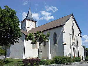
 Saint-Benoît church in Grilly |
||
Grilly is a French municipality with 833 inhabitants (at January 1, 2017) in the department of Ain in the region Auvergne Rhône-Alpes . It belongs to the canton of Gex in the Gex arrondissement and is a member of the Pays de Gex community association .
geography
Grilly is located at 513 m , four kilometers east of Gex and about 14 km north of the city of Geneva (as the crow flies). The former farming village extends in the Pays de Gex in a promising elevated position on a plateau at the southern foot of Mont Mourex ( height in front of the Jura ), on the northern edge of the Geneva Basin, near the state border with Switzerland .
The area of the 7.50 km² municipal area covers a section of the Pays de Gex. The south-eastern border runs along the Versoix , which drains the area to Lake Geneva . The brook flows with several meanders through a wide, partly swampy valley low ( Pré Nouveau ). From the floodplain, the community area extends northwest to the 1 km wide and 3 km long plateau of Grilly and the adjacent Mont Mourex . Here, at 754 m, the highest point in Grilly is reached. The mountain is partly forested, partly covered by meadows and has a gently sloping southern slope. The municipality is part of the Upper Jura Regional Nature Park (French: Parc naturel régional du Haut-Jura ).
The village of Mourex ( 651 m ) belongs to Grilly, in a panoramic position on the southern slope of Mont Mourex. Neighboring communities of Grilly are Sauverny and Cessy in the south, Gex in the west, Vesancy and Divonne-les-Bains in the north and the Swiss communities Chavannes-des-Bois and Versoix in the east.
history
The municipality of Grilly was already settled in prehistoric times as well as during Roman times. The place is first mentioned in 1126 under the name Graillie . Over time, the spelling changed from Graliacus (1271), Grellie (1277), Greillier (1332), Greyllie (1365), Grilier (1390), Greylliacus (1397), Greylliez (1573), Greylly (1660) to the current one Name Grilly, which has been documented since 1691. The place name goes back to the Gallo-Roman surname Gralius and means something like Gralius' estate .
Since the Middle Ages , Grilly formed its own small rule, which initially depended on the Counts of Geneva and then came to the Counts of Savoy in the 14th century. Then Grilly shared the checkered history of the Pays de Gex , with which it finally came to France after the conclusion of the Treaty of Lyon in 1601.
Attractions
The parish church of Saint-Benoît originally dates from the 15th century, but was largely rebuilt in the 19th century. Parts of the previous building, for example two Gothic side chapels, were included. The Château de Grilly was built in the 15th century and remodeled in the 18th century. A tower and parts of the surrounding wall have been preserved from the time it was built. Another former manor house dates from the 13th century. On Mont Mourex there is a stone circle (cromlech) consisting of 10 menhirs .
population
| Population development | |
|---|---|
| year | Residents |
| 1962 | 272 |
| 1968 | 302 |
| 1975 | 418 |
| 1982 | 520 |
| 1990 | 634 |
| 1999 | 612 |
| 2006 | 675 |
| 2014 | 786 |
With 833 inhabitants (as of January 1, 2017) Grilly is one of the small communities in the Ain department. After the population had decreased in the first half of the 20th century, the population has continued to grow steadily since the early 1960s. Numerous new single-family houses were built outside the old town center. The local residents of Grilly are called Grillerand (e) s in French .
Economy and Infrastructure
Until well into the 20th century, Grilly was a predominantly agricultural village. Today there are some small and medium-sized businesses. In the meantime the village has turned into a residential community. Many workers are commuters who work in the larger towns of the Pays de Gex or as cross-border commuters in the agglomeration of Geneva.
The place is well developed in terms of traffic. It is located on the D15 departmental road from Ferney-Voltaire to Divonne-les-Bains. Further road connections exist with Gex and Cessy. The closest connection to the Swiss A1 motorway is around 6 km away. The former railway line , which ran from Bellegarde-sur-Valserine to Divonne-les-Bains and also served Grilly, was closed. A bus line operates in their place today.
There is a private pre-school ( école maternelle ) in Grilly .
Web links
Individual evidence
- ↑ Grilly - notice communal. In: cassini.ehess.fr. Retrieved June 10, 2015 (French, INSEE population from 1968 ).
