Vesancy
| Vesancy | ||
|---|---|---|

|
|
|
| region | Auvergne-Rhône-Alpes | |
| Department | Ain | |
| Arrondissement | Gex | |
| Canton | Gex | |
| Community association | Pays de Gex | |
| Coordinates | 46 ° 21 ′ N , 6 ° 5 ′ E | |
| height | 582-1,490 m | |
| surface | 10.70 km 2 | |
| Residents | 484 (January 1, 2017) | |
| Population density | 45 inhabitants / km 2 | |
| Post Code | 01170 | |
| INSEE code | 01436 | |
| Website | www.vesancy.fr | |
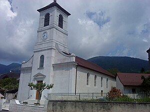
 Saint-Christophe Church in Vesancy |
||
Vesancy is a French municipality with 484 inhabitants (at January 1, 2017) in the department of Ain in the region Auvergne Rhône-Alpes . It belongs to the canton of Gex in the Gex arrondissement and is a member of the Pays de Gex community association .
geography
Vesancy is located at 660 m , three kilometers northeast of Gex and about 16 kilometers north of the city of Geneva (as the crow flies). The former farming village extends in the Pays de Gex in a promising elevated position at the foot of the Jura , on the northern edge of the Geneva basin.
The area of the 10.70 km² municipal area covers a section of the Pays de Gex. The southern part of the municipality is occupied by a wide valley basin that lies between the Jura chain and the upstream Mont Mourex ( 754 m ) and is drained through the Oudar to the south to the Versoix . To the north, the municipal area extends over the gently sloping and meadow slope of Vesancy and the densely wooded steep slope to the broad ridge of the foremost Jura range, on which the forest clearing La Vesancière is located. The highest point of Vesancy is reached on the Jura ridge at 1503 m . The municipality is part of the Upper Jura Regional Nature Park (French: Parc naturel régional du Haut-Jura ).
Neighboring communities of Vesancy are Mijoux in the north, Divonne-les-Bains in the east, Grilly in the south and Gex in the west.
history
Vesancy is mentioned for the first time shortly before the year 1200 under the name Vizencie . Over the centuries, the spelling changed from Vissencie (1297), Visencier (1298), Visenciez (1526), Vesanci (1589) and Vesency (1730) to today's Vesancy (documented in 1734). The place name probably goes back to the Gallo-Roman personal name Vicentius .
Since the Middle Ages , Vesancy formed a small lordship that came to the Counts of Savoy around 1292. From the 14th century, the place shared the eventful history of Gex.
Attractions
The parish church of Saint-Christophe was built in 1846 on the site of a previous church. In the center of the village is the castle with its towers, originally dating from the 12th century, which today serves as the seat of the municipal administration. The Chapelle de Riamont, which was built in 1868, is on a promontory above the village.
population
| Population development | |
|---|---|
| year | Residents |
| 1962 | 289 |
| 1968 | 245 |
| 1975 | 290 |
| 1982 | 295 |
| 1990 | 363 |
| 1999 | 449 |
| 2006 | 508 |
| 2017 | 484 |
With 484 inhabitants (as of January 1, 2017) Vesancy is one of the small communities in the Ain department. After the population had decreased significantly in the first half of the 20th century, the population has continued to grow again since the early 1970s. Numerous new single-family houses were built outside the old town center.
Economy and Infrastructure
Vesancy was a predominantly agricultural village well into the 20th century . Today there are some small and medium-sized businesses. In the meantime the village has turned into a residential community. Many workers are commuters who work as cross-border commuters in the Geneva agglomeration.
The village is off the main thoroughfares, but is easily accessible from Gex and Divonne-les-Bains. The closest connection to the Swiss A1 motorway is around eight kilometers away.
In Vesancy there is a state primary school ( école élémentaire ).
Web links
Individual evidence
- ↑ French Statistics Institute ( www.insee.fr )
- ^ Vesancy - notice communal. In: cassini.ehess.fr. Retrieved on June 3, 2015 (French, INSEE population from 1968 ).
