Farges
| Farges | ||
|---|---|---|

|
|
|
| region | Auvergne-Rhône-Alpes | |
| Department | Ain | |
| Arrondissement | Gex | |
| Canton | Thoiry | |
| Community association | Pays de Gex | |
| Coordinates | 46 ° 10 ′ N , 5 ° 54 ′ E | |
| height | 360-1,527 m | |
| surface | 14.28 km 2 | |
| Residents | 1,038 (January 1, 2017) | |
| Population density | 73 inhabitants / km 2 | |
| Post Code | 01550 | |
| INSEE code | 01158 | |
| Website | www.mairie-farges.fr | |
Farges is a French commune with 1,038 inhabitants (at January 1, 2017) in the department of Ain in the region Auvergne Rhône-Alpes . It belongs to the canton of Thoiry in the Gex arrondissement and is a member of the Pays de Gex municipal association .
geography
Farges is located at 513 m , about 22 km south-southwest of the town of Gex and 19 kilometers west of the city of Geneva (as the crow flies). The former farming village extends in the Pays de Gex at a promising elevated position at the foot of the Jura below the Grand Crêt d'Eau , on the western edge of the Geneva basin.
The area of the 14.28 km² municipal area covers a section of the Pays de Gex. The area is divided into two naturally very different parts. The eastern part is occupied by the fertile plain at the foot of the Jura. This plateau, a molasse basin that was shaped by the Ice Age Rhone glacier , is drained from the Biaz and its source streams eastwards to the Annaz (right tributary of the Rhone ). The streams flow through erosion channels cut more or less deeply into the plateau . While parts of the plateau are forest-covered ( Bois Maillet and Bois de Ban ), others are used for agriculture. The plateau gradually rises towards the Jura.
To the west, the community area extends over the steep, densely wooded slope to the ridge of the foremost Jura chain. The border runs on the ridge, which here forms a small saddle with the Col du Sac . On the northern roof of the Grand Crêt d'Eau, the highest point in Farges is reached at 1527 m . The municipality is part of the Upper Jura Regional Nature Park (French: Parc naturel régional du Haut-Jura ).
In addition to the original location, Farges also includes various hamlets and farms, including:
- Airans ( 525 m ) at the foot of the Jura south-west of the village
- Asserans ( 447 m ) on the plateau above the Biaz valley cut
Neighboring communities of Farges are Péron in the north, Pougny in the east, Collonges in the south and Confort and Chézery-Forens in the west.
history
Farges is first mentioned in a document in 1337 under the name Apud Farges . The names de Fargiis (1397) and Mensura de Farges (1497) have survived from a later period . The place name goes back to the old French word farge (forge).
In the 14th century the village came under the sovereignty of the Counts of Savoy . Farges then shared the checkered history of the Pays de Gex , with which it finally came to France after the conclusion of the Treaty of Lyon in 1601. In the 17th century Farges formed its own small rule. The priory in Asserans, founded by the monks of Nantua in the 13th century, was destroyed by the Bernese in 1536.
Attractions
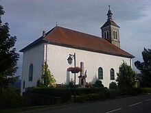
The parish church of Saint-Brice was built at the beginning of the 19th century. The square tower, which served as a keep, has been preserved from the former mansion. The Château de Lapeyrouse dates from the early 19th century.
population
| Population development | |
|---|---|
| year | Residents |
| 1962 | 365 |
| 1968 | 415 |
| 1975 | 456 |
| 1982 | 480 |
| 1990 | 559 |
| 1999 | 594 |
| 2006 | 795 |
| 2011 | 901 |
With 1,038 inhabitants (as of January 1, 2017) Farges is one of the smaller communities in the Ain department. The population has grown significantly since the mid-1960s and has increased further since 2000. Numerous new single-family houses were built outside the old town center. The locals of Farges are called Fargeois (es) in French .
Economy and Infrastructure
Farges was a predominantly agricultural village well into the 20th century . Today there are some local small businesses. In the meantime, the village has also turned into a residential community. Many workers are commuters who work in the larger towns of the Pays de Gex or as cross-border commuters in the agglomeration of Geneva.
The place is well developed in terms of traffic. It is located on the D984 departmental road that runs from Collonges along the foot of the Jura to Saint-Genis-Pouilly . This was relieved by the construction of the four-lane expressway D884 through the Pays de Gex. Another road connection is with Pougny. The former railway line , which ran from Bellegarde-sur-Valserine to Divonne-les-Bains and also served Farges, was closed. A bus line operates in their place today.
In Farges there is a state école primaire (elementary school with an integrated preschool ).
Web links
Individual evidence
- ↑ French Statistics Institute ( www.insee.fr )
- ^ Farges - notice communale. In: cassini.ehess.fr. Retrieved June 28, 2015 (French, INSEE population from 1968 onwards ).

