
Bourg-en-Bresse
| Bourg-en-Bresse | ||
|---|---|---|

|
|
|
| region | Auvergne-Rhône-Alpes | |
| Department | Ain | |
| Arrondissement | Bourg-en-Bresse | |
| Canton |
Bourg-en-Bresse-1 Bourg-en-Bresse-2 |
|
| Community association | Bassin de Bourg-en-Bresse | |
| Coordinates | 46 ° 12 ' N , 5 ° 14' E | |
| height | 220-273 m | |
| surface | 23.86 km 2 | |
| Residents | 41,527 (January 1, 2017) | |
| Population density | 1,740 inhabitants / km 2 | |
| Post Code | 01000 | |
| INSEE code | 01053 | |
| Website | www.bourg-en-bresse.org | |
 Street in Bourg-en-Bresse |
||

Bourg-en-Bresse ([ ˌbuʀ k ɑ̃ˈbʀɛs ]) is a municipality with 41,527 inhabitants (as of January 1, 2017) in eastern France . It is located in the Auvergne-Rhône-Alpes region and is the capital of the Ain department and the seat of the Bassin de Bourg-en-Bresse municipal association . The inhabitants are called Burgiens , those of the Bresse Bressan countryside .
geography
Bourg-en-Bresse is located on the western edge of the French Jura , on the left bank of the Reyssouze , a tributary of the Saône . Lyon is about 70 kilometers southwest and Lons-le-Saunier 50 kilometers north, Mâcon 30 kilometers west and Geneva 120 kilometers east of the city.
coat of arms
Blazon : Split in green and black, above the split lies a silver trefoil cross .
history
Apart from numerous Roman excavations, little is known of the city's early history. Bourg-en-Bresse received town charter in 1250; At the beginning of the 15th century, the city was made the capital of the province of Bresse by the Dukes of Savoy . In 1535, Bourg-en-Bresse fell to France, but was retaken by Duke Emanuel Philibert . He had the city fortified and so it withstood a six-month siege by the troops of Henry IV. From this time there are still many, even smaller, bourgeois houses such as the house Rue de la République 30 . In 1601, Bourg-en-Bresse was finally ceded to France.
During the Second World War , after the capitulation of the French armed forces , Bourg initially belonged to the zone libre , which was under the administration of the Vichy regime . In November 1942 the city was occupied by German troops for almost two years as part of the Anton company ; on September 4, 1944, Bourg-en-Bresse was liberated by the American army.
Population development
| year | 1962 | 1968 | 1975 | 1982 | 1990 | 1999 | 2007 | 2016 |
| Residents | 32,596 | 37,887 | 42.181 | 41,098 | 40,972 | 40,666 | 40.506 | 41,365 |
Attractions
- The Royal Monastery of Brou with a large abbey church was built between 1505 and 1536; it contains the tombs of Marguerite de Bourbon, Philibert and Margaret of Austria.
- The Gothic co-cathedral Notre-Dame de Bourg (1505–1695) has a Renaissance facade from the 16th century. The portal dates from 1545. The tower was built between 1652 and 1695, cut during the French Revolution and reconstructed in 1914.
- The Musée de Brou shows a collection of French, Flemish and Italian art from the 15th to the 20th centuries.
- L'Hôtel-Dieu (17th century) with apothicairerie (historic pharmacy)
- The castle of the Dukes of Bresse
- Porte des Jacobins (15th century)
- In the city center there are many buildings from the 15th and 16th centuries. a. the theater, the Grenette district, the Kiosque à musique des Quinconces and the old Jesuit college.
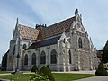
Church of the Brou Monastery

Interior of the church
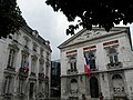
City Hall


.jpg)
Town twinning
Bourg-en-Bresse maintains town twinning with:
|
|
Sports
The most famous sports clubs are the US Bressane , which plays rugby union , and the FC Bourg-Péronnas football club .
Personalities
- Claude Charles Aubry de La Boucharderie (1773-1813), general of the artillery
- Julien Benneteau (* 1981), tennis player
- Émilien Cabuchet (1819–1902), sculptor
- François Clerc (* 1983), national soccer player
- Aimé Auguste Cotton (1869–1951), physicist
- Charles Démia (1637–1689), educator and founder of the order
- Jacques Di Donato (born 1942), musician
- Nicolas Faret (1596–1646), politician and author
- Paul Fromin (* 1950), composer and musician
- Alain Giletti (* 1939), figure skater
- André Guy (* 1941), football player
- Jean-Pierre Hanrioud (* 1936), racing car driver
- Marianne Hoepfner (* 1944), racing car driver
- Luc Jacquet (* 1967), biologist and director
- Jérôme Lalande (1732–1807), mathematician and astronomer
- Lou Lecaudey (* 1990), jazz musician
- Daniel Morelon (* 1944), racing cyclist
- Lionel Nallet (* 1976), captain of the French rugby union national team
- Peggy Provost (* 1977), soccer player
- Edgar Quinet (1803–1875), writer and historian
- Jean-Charles Richard (* 1974), jazz musician
Web links
Individual evidence
- ^ Bourg-en-Bresse (01000) et ses habitants les Burgiens, Burgiennes. habitants.fr, accessed November 22, 2012 .
- ^ André Buisson: Carte Archéologique de la Gaule - Ain 01 . Académie des Inscriptions et Belles-Lettres , 1990, ISBN 2-87754-010-3 , pp. 51–57 (French, online [accessed January 18, 2014]).
- ^ Film Liberation de Bourg Ain par le sergent Fred Bornet YouTube of March 4, 2012. Accessed January 20, 2019.
- ^ Website of the city