
Montluel
| Montluel | ||
|---|---|---|
.svg)
|
|
|
| region | Auvergne-Rhône-Alpes | |
| Department | Ain | |
| Arrondissement | Bourg-en-Bresse | |
| Canton | Meximieux | |
| Community association | Côtière à Montluel | |
| Coordinates | 45 ° 51 ' N , 5 ° 3' E | |
| height | 192-312 m | |
| surface | 40.11 km 2 | |
| Residents | 6,964 (January 1, 2017) | |
| Population density | 174 inhabitants / km 2 | |
| Post Code | 01120 | |
| INSEE code | 01262 | |
| Website | www.ville-montluel.fr | |
 Place Colbert |
||

Montluel is a French commune with 6964 inhabitants (as of January 1, 2017) in the Ain department in the Auvergne-Rhône-Alpes region . It belongs to the arrondissement of Bourg-en-Bresse and the canton of Meximieux . As a member of the communal association Communauté de communes de la Côtière à Montluel , it is also its administrative seat.
geography
The municipality of Montluel is located on the Sereine , about 15 kilometers northeast of Lyon in the Côtière landscape , which merges into the Dombes in the north and is bordered by the Rhône in the south . The settlement area of Montluel merges seamlessly with that of the municipality of Dagneux in the east, and with the area of the municipality of La Boisse in the southwest . This settlement axis has developed rapidly since the 1960s due to its proximity to Lyon and the A 42 - A 432 motorway junction and the settlement of many companies.
Neighboring municipalities of Montluel are Birieux , Le Montellier and Sainte-Croix in the north, Pizay in the northeast, Dagneux in the east, La Boisse in the southwest and Tramoyes , Mionnay , Saint-André-de-Corcy and Saint-Marcel in the northwest.
Population development
| year | 1962 | 1968 | 1975 | 1982 | 1990 | 1999 | 2006 | 2011 | 2016 |
|---|---|---|---|---|---|---|---|---|---|
| Residents | 2785 | 3442 | 4604 | 5450 | 5954 | 6456 | 6478 | 7112 | 7005 |

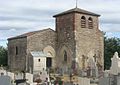
Notre Dame des Marais church
Chapel of St. Bartholomew

Ruin of the castle


Architectural monuments
See: List of Monuments historiques in Montluel
Community partnerships
There is a community partnership with Ostfildern .
Web links
- Community presentation (French)