
Certines
| Certines | ||
|---|---|---|
|
||
| region | Auvergne-Rhône-Alpes | |
| Department | Ain | |
| Arrondissement | Bourg-en-Bresse | |
| Canton | Ceyzériat | |
| Community association | Bassin de Bourg-en-Bresse | |
| Coordinates | 46 ° 8 ' N , 5 ° 16' E | |
| height | 243-277 m | |
| surface | 15.92 km 2 | |
| Residents | 1,517 (January 1, 2017) | |
| Population density | 95 inhabitants / km 2 | |
| Post Code | 01240 | |
| INSEE code | 01069 | |
| Website | www.certines.fr | |
 The Certines Municipal Council ( mairie ) |
||

Certines is a French commune with 1,517 inhabitants (at January 1, 2017) in the department of Ain in the region Auvergne Rhône-Alpes . It belongs to the canton of Ceyzériat in the arrondissement of Bourg-en-Bresse .
geography
location
Certines is located at 250 m , about nine kilometers south of the prefecture of Bourg-en-Bresse , 53 km northeast of the city of Lyon and 38 km east-southeast of the city of Mâcon (as the crow flies). The village extends in the south-eastern part of the historical Bresse province . Certines' neighboring municipalities are Montagnat in the north, Tossiat and Saint-Martin-du-Mont in the east, La Tranclière in the south and Lent and Péronnas in the west.
topography
The area of the municipal area of 15.92 km² includes a section in the southern part of the Bresse, a plain in the Bresse-Saône ditch . Its south-western part is already characterized by the wooded lake landscape typical of the Dombes . The hills and valleys distributed over the municipality reach height differences of only a few meters. To the southwest, the community soil rises evenly to a height of 277 m , it is drained in the opposite direction via several streams and ditches to the Reyssouze (river) . In addition to the large communal areas of forest in the west, which together make up almost 32% of the land cover, the remaining undeveloped portion is largely used for agriculture.
Community structure
The village of Les Rippes ( 251 m ) belongs to Certines in the north , to which the settlements Portant and Les Jallatières adjoin. Several farmsteads are grouped around the actual town center.
history
In the Middle Ages there was a priory in Certines , which was first mentioned in 1250 and which belonged to the Saint-André-le-Haut convent in Vienne . Its spelling, as well as that of the town recorded from 1310, was then Essartines , it changed from Essertines (1325), Sartines (1564) and Sertines (1650) to Certines (1655).
In the administrative structure after the French Revolution , Certines belonged to the canton of Pont-d'Ain until 2015 , after which it moved to the canton of Ceyzériat as part of the nationwide reorganization of the cantons .
Attractions
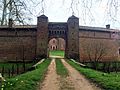
- The Château de Genoud south of the village is a brick building whose origins go back to the early years of the 14th century. Originally the château consisted of three towers with two drawbridges, which were removed during the French Revolution . The main rectangular tower was rebuilt around 1853. It is followed by the Corps de Logis from 1672, the interior of which dates from the 19th century. Farm buildings arranged in a semicircle are arranged to the right and left of the entrance gate.
- The village church of Saint-Christophe is part of the parish of Tossiat. There is a chapel in Les Rippes.

Château de Genoud (west or entrance side)
Gate and farm building of the Château de Genoud

Certines village church

The chapel of Les Rippes


population
| Population development | |
|---|---|
| year | Residents |
| 1962 | 397 |
| 1968 | 429 |
| 1975 | 491 |
| 1982 | 675 |
| 1990 | 916 |
| 1999 | 1,288 |
| 2006 | 1,414 |
| 2016 | 1,532 |
With 1517 inhabitants (as of January 1, 2017) Certines is one of the smaller communities in the Ain department. After the population had risen to 524 by the end of the 19th century, it fell back to 397 in the first half of the 20th century. The population has increased again since the 1970s. The locals of Certines are called Certinois (es) in French .
Economy and Infrastructure
Certines is still a predominantly agricultural village. There are also various local small-scale businesses and some medium-sized businesses. In the meantime the village has also developed into a residential community. Many workers are commuters who work in the larger towns in the area, especially in the Bourg-en-Bresse area.
The village is not far from the D1075 departmental road and the former N75 national road that connected Bourg-en-Bresse with Grenoble. From here, as well as from the surrounding villages, side roads lead to Certines. In the northeast, directly behind the municipal boundary with Tossiat, is the next motorway connection to the A40 , which crosses the municipality in the east. The Mâcon – Ambérieu-en-Bugey railway, which has a larger train station in Bourg-en-Bresse, runs along the eastern edge of the municipality . The airport in the region is Lyon-St-Exupéry (70 km away).
Web links
Individual evidence
- ↑ 2006 data from CORINE Land Cover , available e.g. B. at www.statistiques.developpement-durable.gouv.fr ( Memento of the original from March 24, 2016 in the Internet Archive ) Info: The archive link has been inserted automatically and has not yet been checked. Please check the original and archive link according to the instructions and then remove this notice. .
- ↑ É. Philipon: Dictionnaire Topographique du Département de l'Ain . Imprimerie Nationale, 1911, p. 79 (French, online [PDF; accessed January 4, 2014]).
- ^ Château de Genoud in the Base Mérimée of the French Ministry of Culture (French).
- ↑ French Statistics Institute ( www.insee.fr )
- ^ Certines - notice communale. In: cassini.ehess.fr. Retrieved on March 26, 2016 (French, INSEE population from 1968 ).
- ↑ Commune de Certines - Complete dossier. In: INSEE . Retrieved March 26, 2016 (French).