
Dompierre-sur-Chalaronne
| Dompierre-sur-Chalaronne | ||
|---|---|---|
|
||
| region | Auvergne-Rhône-Alpes | |
| Department | Ain | |
| Arrondissement | Bourg-en-Bresse | |
| Canton | Châtillon-sur-Chalaronne | |
| Community association | Dombes | |
| Coordinates | 46 ° 9 ' N , 4 ° 54' E | |
| height | 200-262 m | |
| surface | 4.78 km 2 | |
| Residents | 435 (January 1, 2017) | |
| Population density | 91 inhabitants / km 2 | |
| Post Code | 01400 | |
| INSEE code | 01146 | |
 Mairie Dompierre-sur-Chalaronne |
||

Dompierre-sur-Chalaronne is a French municipality with 435 inhabitants (at January 1, 2017) in the department of Ain in the region Auvergne Rhône-Alpes . It belongs to the canton of Châtillon-sur-Chalaronne in the Bourg-en-Bresse arrondissement . It borders on Saint-Étienne-sur-Chalaronne , L'Abergement-Clémenciat and Baneins .
Population development
| year | 1962 | 1968 | 1975 | 1982 | 1990 | 1999 | 2008 | 2014 |
|---|---|---|---|---|---|---|---|---|
| Residents | 156 | 156 | 154 | 183 | 268 | 279 | 371 | 416 |
Attractions
- Saint-Georges church
- Salle Yves Mercier
- War memorial
- Water tower
- Field cross "Croix du Barvet"
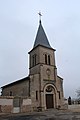
Saint-Georges church

Salle Yves Mercier
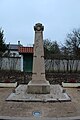
War memorial

Water tower

Floor cross
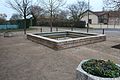
Fountain at the Mairie


Web links
Commons : Dompierre-sur-Chalaronne - Collection of images, videos and audio files