
Lurcy
| Lurcy | ||
|---|---|---|
|
||
| region | Auvergne-Rhône-Alpes | |
| Department | Ain | |
| Arrondissement | Bourg-en-Bresse | |
| Canton | Villars-les-Dombes | |
| Community association | Val de Saone Center | |
| Coordinates | 46 ° 4 ' N , 4 ° 47' E | |
| height | 169-233 m | |
| surface | 4.81 km 2 | |
| Residents | 384 (January 1, 2017) | |
| Population density | 80 inhabitants / km 2 | |
| Post Code | 01090 | |
| INSEE code | 01225 | |
 Mairie Lurcy |
||

Lurcy is a French commune in the Ain department in the region of Auvergne Rhône-Alpes . It belongs to the canton of Villars-les-Dombes in the Bourg-en-Bresse arrondissement . It borders on Saint-Georges-de-Reneins to the west, Montmerle-sur-Saône to the north-west, Francheleins to the north and east, Chaleins to the south-east and Messimy-sur-Saône to the south-west . In the west, the Saône forms the border with the Rhône department . The inhabitants call themselves Luperciens .
Population development
| year | 1962 | 1968 | 1975 | 1982 | 1990 | 1999 | 2008 | 2014 |
|---|---|---|---|---|---|---|---|---|
| Residents | 225 | 194 | 182 | 197 | 199 | 257 | 395 | 395 |
Attractions
- Saint-Etienne church from the 9th century
- War memorial
- Lurcy Castle from the 14th century
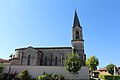
Saint-Etienne church
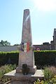
War memorial


Web links
Commons : Lurcy - collection of images, videos and audio files