
Romans (Ain)
| Romans | ||
|---|---|---|
.svg)
|
|
|
| region | Auvergne-Rhône-Alpes | |
| Department | Ain | |
| Arrondissement | Bourg-en-Bresse | |
| Canton | Châtillon-sur-Chalaronne | |
| Community association | Dombes | |
| Coordinates | 46 ° 7 ' N , 5 ° 1' E | |
| height | 227-280 m | |
| surface | 22.32 km 2 | |
| Residents | 590 (January 1, 2017) | |
| Population density | 26 inhabitants / km 2 | |
| Post Code | 01400 | |
| INSEE code | 01328 | |
 Town Hall (Mairie) by Romans |
||

Romans is a French municipality with 590 inhabitants (as of January 1 2017) in the department of Ain in the region Auvergne Rhône-Alpes . It belongs to the canton of Châtillon-sur-Chalaronne in the Bourg-en-Bresse arrondissement . The inhabitants are called Romanais .
geography
Romans is on the border between the Bresse and Dombes landscapes , about 16 kilometers southwest of the prefecture of Bourg-en-Bresse on the Renon River . Romans is surrounded by the neighboring communities of Neuville-les-Dames in the north, Condeissiat in the north-east, Saint-André-le-Bouchoux in the east and south-east, Saint-Georges-sur-Renon and La Chapelle-du-Châtelard in the south, Sandrans in the south and southwest and Châtillon-sur-Chalaronne to the west.
Population development
| year | 1962 | 1968 | 1975 | 1982 | 1990 | 1999 | 2006 | 2013 |
| Residents | 353 | 367 | 346 | 351 | 480 | 522 | 571 | 602 |
| Source: Cassini and INSEE | ||||||||
Attractions
- Saint-Maurice church, originally from the 12th century, rebuilt from 1856 to 1858
- Romans Castle from the 15th century
- Le Chapuis Castle
- Clerdan Castle
- Beaujeu Castle
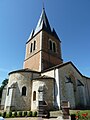
Saint-Maurice Church
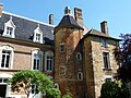
Castle Romans

.JPG)