
Saint-Cyr-sur-Menthon
| Saint-Cyr-sur-Menthon | ||
|---|---|---|
.svg)
|
|
|
| region | Auvergne-Rhône-Alpes | |
| Department | Ain | |
| Arrondissement | Bourg-en-Bresse | |
| Canton | Vonnas | |
| Community association | Veyle | |
| Coordinates | 46 ° 17 ′ N , 4 ° 58 ′ E | |
| height | 181-217 m | |
| surface | 16.93 km 2 | |
| Residents | 1,776 (January 1, 2017) | |
| Population density | 105 inhabitants / km 2 | |
| Post Code | 01380 | |
| INSEE code | 01343 | |
| Website | mairie-saint-cyr-sur-menthon.fr | |
 Village church of Saint-Cyr-sur-Menthon |
||

Saint-Cyr-sur-Menthon is a French commune with 1,776 inhabitants (at January 1, 2017) in the department of Ain in the region Auvergne Rhône-Alpes . It belongs to the canton of Vonnas in the Bourg-en-Bresse arrondissement .
geography
location
Saint-Cyr-sur-Menthon is located at 208 m , about 21 kilometers west-northwest of the prefecture of Bourg-en-Bresse , 11 km east of the city of Mâcon and 58 km north of the city of Lyon (as the crow flies). The village extends in the southern part of the historical Bresse province . Neighboring municipalities of Saint-Cyr-sur-Menthon are Bâgé-Dommartin in the north, Saint-Genis-sur-Menthon in the east, Perrex in the south and Saint-Jean-sur-Veyle in the west.
topography
The area of the 16.93 km 2 municipality covers part of the southern Bresse, a low relief plain in the Bresse-Saône Graben , which extends east of the Saône. The municipal area is essentially drained by the Menthon to the southwest towards the Veyle , a left tributary of the Saône. Also in the northwest of the municipality, there are some channel conversations that the Virolet are connected. The municipal area is divided into three similarly sized parts: a central part with the village center, an eastern part on the other side of the Menthon and a northern part on the other side of the A40 motorway , the route of which crosses the municipality. With shares of 48% and 37% respectively, fields and other agricultural land make up the main use of the municipal land, followed by meadows (8%) and forests (4%).

Community structure
In addition to the actual town center, Saint-Cyr-sur-Menthon has many other parts of the municipality, hamlet settlements and farmsteads that are scattered across the municipality. The more important of these are:
- La Mulatière ( 214 m ) north of the A40, surrounded by the hamlets of Les Mirtanges, La Manche and Piquerand,
- Les Croix Vieilles ( 211 m ) south of the A40 and in the very east of the municipality,
- La Tuilerie ( 214 m ) on the main road west of Saint-Cyr,
- Les Chanelets ( 205 m ) north of Saint-Cyr,
- Les Druillets ( 210 m ) and Les Gambys ( 198 m ) on the southern edge of the municipality,
- Aringe ( 203 m ) and Marillat ( 191 m ) on the other side of the Menthon.
history

Roman bricks and a small coin treasure containing sesterces from the time until Emperor Severus Alexander were found at two different places in the municipality .
In the High Middle Ages there was a small manor with a motte and a permanent house in Saint-Cyr , in which a family of the same name resided in the 11th century and which depended on the rule of Bâgé . At the same time, the place had a church that was first mentioned in 994 ( Ecclesia que est in honore Sancti Cirici ). Their patronage is St. Quiricus , the addition -sur- menthon first appeared in 1442. The present-day hamlet of Aringe has also existed since at least the 10th century, when it was mentioned under the names Ariangas and Aringas . The other hamlets have been documented since the 14th and 15th centuries at the earliest ( Apud lo Drulliey , 1359 and Villagium Millaterie , 1493).
In 1272, the county of Savoy took over the sovereignty of Saint-Cyr, when the Bâgé family died out in the male line and sole heiress Sibylle de Bâgé brought her lands as a dowry in the marriage with Amadeus V of Savoy. The von Saint-Cyr family was able to renew their fiefdom. As part of the Bresse, Saint-Cyr came to the Kingdom of France with the Treaty of Lyon in 1601.
Attractions

In Saint-Cyr-sur-Menthon there are four farms, mostly from the 17th century, which are built in the typical Bresse style, that is, made of timber framework that is filled with adobe bricks. Their Saracen chimneys are each classified as monument historique . The courtyards are: Ferme dite de la Grange du Clou (17th century, entire building under monument protection), Grange des Carons , Ferme à Tavernay and Ferme des Planons (14th – 17th centuries). Three of them are in La Mulatière, with the Ferme des Planons today being the centerpiece of the Bresse museum, Musée départemental de la Bresse - Domaine des Planons . In addition to the architecture of a typical Bresse farm, it explains customs and historical everyday life in the Bresse and is partly designed as an open-air museum with a 20 hectare park. In addition to the courtyard group, there is a modern main building built in 2005 and a second access via its own motorway parking lot on the A40.
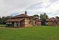
Ferme de la Grange du Clou
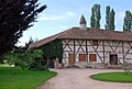
Ferme de Tavernay

Grange des Carons

Park and mill weir on the Menthon


The village church was built in the middle of the 19th century in neo-Gothic style and replaced the previous medieval building. On the banks of the Menthon there is a small park with a renovated old mill.
population
| Population development | |
|---|---|
| year | Residents |
| 1962 | 811 |
| 1968 | 809 |
| 1975 | 822 |
| 1982 | 983 |
| 1990 | 1,243 |
| 1999 | 1.314 |
| 2006 | 1,515 |
| 2011 | 1,674 |
With 1,776 inhabitants (as of January 1, 2017), Saint-Cyr-sur-Menthon is one of the smaller communities in the Ain department. After the population had reached a historic high of 1414 in 1856, it declined in the second half of the 19th and first half of the 20th century. The population has increased again since the 1970s and continues to this day. The local residents of Saint-Cyr-sur-Menthon are called Saint-Cyrien (ne) s in French .
Economy and Infrastructure
Saint-Cyr-sur-Menthon is still a predominantly agricultural village with a focus on poultry farming and about a dozen active farms. The Lamberet company, a large manufacturer of box bodies for refrigerated commercial vehicles with around 350 jobs in the community, has its headquarters in the Les Teppes industrial park . There are also various local small businesses. In the meantime the village has also developed into a residential community. Many workers are commuters who work in the larger towns in the area, especially in the Bourg-en-Bresse area but also in Mâcon.

The village is on the department road and the former national road D1079 Mâcon – Bourg-en-Bresse. A network of side streets opens up the hamlets and farmsteads and continues to the southern and northern neighboring communities. The next partial junctions to the A40 are around 4 and 8 km away. The Mâcon – Ambérieu-en-Bugey railway runs south of Saint-Cyr-sur-Menthon, with several TER Rhône-Alpes stops and TGV stations in Mâcon and Bourg-en-Bresse. The airport in the region is Lyon-St-Exupéry (75 km).
Web links
Individual evidence
- ↑ 2006 data from CORINE Land Cover , available e.g. B. at www.statistiques.developpement-durable.gouv.fr ( Memento of the original from March 24, 2016 in the Internet Archive ) Info: The archive link has been inserted automatically and has not yet been checked. Please check the original and archive link according to the instructions and then remove this notice. .
- ^ André Buisson: Carte Archéologique de la Gaule - Ain 01 . Académie des Inscriptions et Belles-Lettres , 1990, ISBN 2-87754-010-3 , pp. 131 (French, limited preview in Google Book search).
- ↑ a b É. Philipon: Dictionnaire Topographique du Département de l'Ain . Imprimerie Nationale, 1911, p. 16, 158, 285, 373 (French, online [PDF; accessed January 4, 2014]).
- ^ Ferme dite de la Grange du Clou, La Mulatière in the Base Mérimée of the French Ministry of Culture (French).
- ↑ PA00116546 Grange des Carons, La Mulatière in the Base Mérimée of the French Ministry of Culture (French).
- ^ Ferme à Tavernay in the Base Mérimée of the French Ministry of Culture (French).
- ↑ Ferme des Planons in the Base Mérimée of the French Ministry of Culture (French).
- ↑ French Statistics Institute ( www.insee.fr )
- ↑ Saint-Cyr-sur-Menthon - notice communale. In: cassini.ehess.fr. Retrieved October 12, 2015 (French, INSEE population from 1968 ).
- ↑ Commune de Saint-Cyr-sur-Menthon - Dossier complet. In: INSEE . Retrieved October 12, 2015 (French).