
Sermoyer
| Sermoyer | ||
|---|---|---|
|
||
| region | Auvergne-Rhône-Alpes | |
| Department | Ain | |
| Arrondissement | Bourg-en-Bresse | |
| Canton | Replonges | |
| Community association | Bresse et Saône | |
| Coordinates | 46 ° 30 ′ N , 4 ° 59 ′ E | |
| height | 168-214 m | |
| surface | 16.7 km 2 | |
| Residents | 668 (January 1, 2017) | |
| Population density | 40 inhabitants / km 2 | |
| Post Code | 01190 | |
| INSEE code | 01402 | |

Sermoyer is a French commune in the Ain department in the region of Auvergne Rhône-Alpes . It belongs to the canton of Replonges in the Bourg-en-Bresse arrondissement . Sermoyer is the northernmost municipality in the Ain department. Neighboring municipalities are Le Villars in the northwest, La Truchère and Ratenelle in the north, Romenay in the northeast, Vescours in the east, Arbigny in the south and Farges-lès-Mâcon in the west. ´
Population development
| year | 1962 | 1968 | 1975 | 1982 | 1990 | 1999 | 2008 | 2014 |
|---|---|---|---|---|---|---|---|---|
| Residents | 552 | 526 | 458 | 515 | 522 | 545 | 664 | 699 |
Attractions
- Saint-Pierre-et-Saint-Paul church
- War memorial

Site of charm: the stone is a monument historique

Saint-Pierre-et-Saint-Paul church
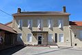
Mairie Sermoyer

Memorial plaque for René Edmond Colin
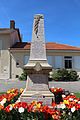
War memorial
_5.jpg)


.jpg)

Web links
Commons : Sermoyer - collection of pictures, videos and audio files