Saint-Denis-lès-Bourg
| Saint-Denis-lès-Bourg | ||
|---|---|---|

|
|
|
| region | Auvergne-Rhône-Alpes | |
| Department | Ain | |
| Arrondissement | Bourg-en-Bresse | |
| Canton | Bourg-en-Bresse-2 | |
| Community association | Bassin de Bourg-en-Bresse | |
| Coordinates | 46 ° 12 ' N , 5 ° 11' E | |
| height | 209-242 m | |
| surface | 12.58 km 2 | |
| Residents | 5,747 (January 1, 2017) | |
| Population density | 457 inhabitants / km 2 | |
| Post Code | 01000 | |
| INSEE code | 01344 | |
| Website | www.ville-saint-denis-les-bourg.fr | |
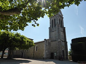
 Saint-Denis church |
||
Saint-Denis-les-Bourg is a commune with 5747 inhabitants (as of January 1 2017) in the department of Ain in the region Auvergne Rhône-Alpes . Administratively, it belongs to the Arrondissement of Bourg-en-Bresse and is part of the canton of Bourg-en-Bresse-2 .
geography
The Veyle flows on the western edge of Saint-Denis-lès-Bourg . Saint-Denis-lès-Bourg is surrounded by the neighboring communities of Viriat in the north and northeast, Bourg-en-Bresse in the east, Péronnas in the south and southeast, Saint-Rémy in the southwest, Buellas in the west and Polliat in the northwest.
history
The place is first mentioned in documents in the 11th century.
Population development
| year | 1962 | 1968 | 1975 | 1982 | 1990 | 1999 | 2006 | 2011 |
| Residents | 1,940 | 2,510 | 3,181 | 3,352 | 4.145 | 4,921 | 4,967 | 5,492 |
Partnerships
We have partnerships with the following municipalities:
- Schutterwald , Baden-Württemberg, Germany, since 1988
- Redea , Wallachia, Romania, since 2000
There is a loose connection to the Indian community of Shantivanam .
Attractions
- Saint-Denis church, built in Gothic style, rebuilt in the 19th century
