
Sandrans
| Sandrans | ||
|---|---|---|
.svg)
|
|
|
| region | Auvergne-Rhône-Alpes | |
| Department | Ain | |
| Arrondissement | Bourg-en-Bresse | |
| Canton | Châtillon-sur-Chalaronne | |
| Community association | Dombes | |
| Coordinates | 46 ° 4 ′ N , 4 ° 59 ′ E | |
| height | 235-291 m | |
| surface | 29.02 km 2 | |
| Residents | 530 (January 1, 2017) | |
| Population density | 18 inhabitants / km 2 | |
| Post Code | 01400 | |
| INSEE code | 01393 | |
| Website | www.sandrans.fr | |

Sandrans is a French municipality with 530 inhabitants (as of January 1, 2017) in the department of Ain in the region Auvergne Rhône-Alpes . It belongs to the canton of Châtillon-sur-Chalaronne in the Bourg-en-Bresse arrondissement . The inhabitants are called Sandranais .
geography
Sandrans is located in the Dombes countryside , about 24 kilometers southwest of the prefecture of Bourg-en-Bresse . The Chalaronne river limits the municipality to the northeast. Sandrans is surrounded by the neighboring communities of Châtillon-sur-Chalaronne in the north, Romans in the northeast, La Chapelle-du-Châtelard in the east, Bouligneux in the south, Saint-Trivier-sur-Moignans in the west and southwest and Relevant in the west and northwest.
Population development
| year | 1962 | 1968 | 1975 | 1982 | 1990 | 1999 | 2006 | 2013 |
| Residents | 416 | 361 | 366 | 379 | 346 | 416 | 502 | 508 |
| Source: Cassini and INSEE | ||||||||
Attractions
- Saint-Priest church from the 12th century ( Monument historique )
- Sandrans Castle
- Bois de Saint-Guignefort
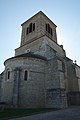
Saint-Priest church

Sandrans Castle

.jpg)