
Le Plantay
| Le Plantay | ||
|---|---|---|
|
||
| region | Auvergne-Rhône-Alpes | |
| Department | Ain | |
| Arrondissement | Bourg-en-Bresse | |
| Canton | Ceyzériat | |
| Community association | Dombes | |
| Coordinates | 46 ° 1 ' N , 5 ° 5' E | |
| height | 267-286 m | |
| surface | 19.96 km 2 | |
| Residents | 564 (January 1, 2017) | |
| Population density | 28 inhabitants / km 2 | |
| Post Code | 01330 | |
| INSEE code | 01299 | |
| Website | http://www.leplantay.wordpress.com/ | |
 Le Plantay Library |
||

Le Plantay is a French municipality with 564 inhabitants (as of January 1 2017) in the department of Ain in the region Auvergne Rhône-Alpes . It belongs to the canton of Ceyzériat (until 2015: canton of Chalamont ) in the arrondissement of Bourg-en-Bresse .
geography
Le Plantay is located about 18 kilometers south-southwest of Bourg-en-Bresse in the Dombes . Neighboring municipalities of Le Plantay are Marlieux in the north, Saint-Nizier-le-Désert in the east and northeast, Chalamont in the east and southeast, Versailleux in the south and southeast and Villars-les-Dombes in the west and southwest.
Population development
| year | 1962 | 1968 | 1975 | 1982 | 1990 | 1999 | 2006 | 2013 |
| Residents | 323 | 300 | 281 | 339 | 344 | 417 | 512 | 527 |
| Source: Cassini and INSEE | ||||||||
Attractions
- Saint-Pierre church, monument historique since 2008
- Le Châtel tower, Monument historique since 1991
- Notre-Dame Monastery, founded in 1863
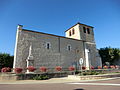
Saint-Pierre church

Notre-Dame des Dombes monastery
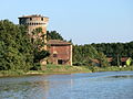
Le Châtel tower


Web links
Commons : Le Plantay - collection of images, videos and audio files