
Saint-Paul-de-Varax
| Saint-Paul-de-Varax | ||
|---|---|---|
|
||
| region | Auvergne-Rhône-Alpes | |
| Department | Ain | |
| Arrondissement | Bourg-en-Bresse | |
| Canton | Châtillon-sur-Chalaronne | |
| Community association | Dombes | |
| Coordinates | 46 ° 6 ' N , 5 ° 8' E | |
| height | 245-281 m | |
| surface | 25.97 km 2 | |
| Residents | 1,529 (January 1, 2017) | |
| Population density | 59 inhabitants / km 2 | |
| Post Code | 01240 | |
| INSEE code | 01383 | |

Saint-Paul-de-Varax is a French commune with 1,529 inhabitants (at January 1, 2017) in the department of Ain in the region Auvergne Rhône-Alpes . It belongs to the canton of Châtillon-sur-Chalaronne in the Bourg-en-Bresse arrondissement .
geography
The municipality of Saint-Paul-de-Varax is located in the middle of the lake landscape of the Dombes , about 14 kilometers southwest of the prefecture of Bourg-en-Bresse and 44 kilometers north-northeast of the city of Lyon (both as the crow flies). The municipality is drained by the Vieux Jonc river in a northerly direction.
Population development
| year | 1962 | 1968 | 1975 | 1982 | 1990 | 1999 | 2006 | 2011 |
| Residents | 721 | 711 | 743 | 1,161 | 1,081 | 1,187 | 1,429 | 1,526 |
Attractions
- Saint-Paul church (12th century), monument historique
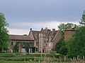
- Castle, Monument historique
- Louis Jourdan Museum

Saint Paul Church
lock

.JPG)
Web links
Commons : Saint-Paul-de-Varax - Collection of images, videos and audio files