
Saint-Nizier-le-Bouchoux
| Saint-Nizier-le-Bouchoux | ||
|---|---|---|
|
||
| region | Auvergne-Rhône-Alpes | |
| Department | Ain | |
| Arrondissement | Bourg-en-Bresse | |
| Canton | Replonges | |
| Community association | Bassin de Bourg-en-Bresse | |
| Coordinates | 46 ° 28 ' N , 5 ° 9' E | |
| height | 192-222 m | |
| surface | 28.3 km 2 | |
| Residents | 680 (January 1, 2017) | |
| Population density | 24 inhabitants / km 2 | |
| Post Code | 01560 | |
| INSEE code | 01380 | |
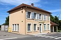
 Mairie Saint-Nizier-le-Bouchoux |
||

Saint-Nizier-le-Bouchoux is a French commune in the Ain department in the region of Auvergne Rhône-Alpes . It belongs to the canton of Replonges in the Bourg-en-Bresse arrondissement . It borders in the north on Curciat-Dongalon , in the north-east on Varennes-Saint-Sauveur , in the east on Cormoz , in the south on Lescheroux , in the south-west on Mantenay-Montlin and in the west on Courtes .
Population development
| year | 1962 | 1968 | 1975 | 1982 | 1990 | 1999 | 2008 | 2014 |
|---|---|---|---|---|---|---|---|---|
| Residents | 1,025 | 886 | 743 | 657 | 625 | 546 | 727 | 685 |
Attractions
- Farm ( Ferme Bourbon ), Monument historique
- Saint-Antoine church
- War memorial

Ferme Bourbon

Saint-Antoine church
mail department
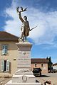
War memorial


Web links
Commons : Saint-Nizier-le-Bouchoux - Collection of images, videos and audio files