
Simandre-sur-Suran
| Simandre-sur-Suran | ||
|---|---|---|
|
||
| region | Auvergne-Rhône-Alpes | |
| Department | Ain | |
| Arrondissement | Bourg-en-Bresse | |
| Canton | Saint-Etienne-du-Bois | |
| Community association | Bassin de Bourg-en-Bresse | |
| Coordinates | 46 ° 14 ' N , 5 ° 25' E | |
| height | 296-644 m | |
| surface | 16.30 km 2 | |
| Residents | 671 (January 1, 2017) | |
| Population density | 41 inhabitants / km 2 | |
| Post Code | 01250 | |
| INSEE code | 01408 | |
 Mairie Simandre-sur-Suran |
||

Simandre-sur-Suran is a French commune in the Ain department in the region of Auvergne Rhône-Alpes . It belongs to the canton of Saint-Étienne-du-Bois in the Bourg-en-Bresse arrondissement . It borders in the north on Chavannes-sur-Suran , in the north-east on Corveissiat , in the south-east on Grand-Corent , in the south on Villereversure , in the south-west on Drom and in the north-west on Treffort-Cuisiat . The name affix testifies to the Suran flowing by .
Population development
| year | 1962 | 1968 | 1975 | 1982 | 1990 | 1999 | 2008 | 2014 |
|---|---|---|---|---|---|---|---|---|
| Residents | 489 | 445 | 402 | 500 | 574 | 638 | 656 | 694 |
Attractions
- Menhir Pierrefiche , Monument historique
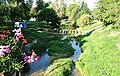
- Charterhouse of Sélignac
- Saint-Antoine church
- War memorial
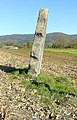
Menhir Pierrefiche

Former post office

Charterhouse of Sélignac

Saint-Antoine church

Fountain on the Mairie

War memorial

Dairy

Tissot Hotel-Restaurant
campsite


Web links
Commons : Simandre-sur-Suran - collection of images, videos and audio files