
Arbigny
| Arbigny | ||
|---|---|---|
|
||
| region | Auvergne-Rhône-Alpes | |
| Department | Ain | |
| Arrondissement | Bourg-en-Bresse | |
| Canton | Replonges | |
| Community association | Bresse et Saône | |
| Coordinates | 46 ° 28 ′ N , 4 ° 58 ′ E | |
| height | 169-214 m | |
| surface | 17.47 km 2 | |
| Residents | 463 (January 1, 2017) | |
| Population density | 27 inhabitants / km 2 | |
| Post Code | 01190 | |
| INSEE code | 01016 | |
 Mairie Arbigny |
||

Arbigny is a French municipality with 463 inhabitants (as of January 1 2017) in the department of Ain in the region Auvergne Rhône-Alpes . It belongs to the canton of Replonges in the Bourg-en-Bresse arrondissement . The inhabitants are called Arbignerons .
geography
Arbigny is located about 35 kilometers northwest of Bourg-en-Bresse in the Bresse on the Saône . Arbigny is surrounded by the neighboring communities of Sermoyer in the north, Vescours in the east, Chavannes-sur-Reyssouze in the south-east, Saint-Bénigne in the south, Uchizy in the west and north-west and Farges-lès-Mâcon in the north-west.
Population development
| year | 1962 | 1968 | 1975 | 1982 | 1990 | 1999 | 2006 | 2017 |
| Residents | 407 | 353 | 334 | 311 | 314 | 332 | 349 | 463 |
| Sources: Cassini and INSEE | ||||||||
Attractions
- Saint-Pierre church
- Remains of the former castle complex
- La Brevette Mill
- Fallen memorial

Saint-Pierre church

La Brevette Mill
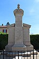
Fallen memorial


Web links
Commons : Arbigny - collection of images, videos and audio files