
Sulignat
| Sulignat | ||
|---|---|---|
|
||
| region | Auvergne-Rhône-Alpes | |
| Department | Ain | |
| Arrondissement | Bourg-en-Bresse | |
| Canton | Châtillon-sur-Chalaronne | |
| Community association | Dombes | |
| Coordinates | 46 ° 11 ′ N , 4 ° 58 ′ E | |
| height | 202-278 m | |
| surface | 10.80 km 2 | |
| Residents | 586 (January 1, 2017) | |
| Population density | 54 inhabitants / km 2 | |
| Post Code | 01400 | |
| INSEE code | 01412 | |

Sulignat is a French commune in the Ain department in the region of Auvergne Rhône-Alpes . It belongs to the canton of Châtillon-sur-Chalaronne in the Bourg-en-Bresse arrondissement . It is bordered by Illiat to the north-west, Saint-Julien-sur-Veyle to the north, Vonnas to the north-west, Neuville-les-Dames to the east, Châtillon-sur-Chalaronne to the south and L'Abergement-Clémenciat to the west . The inhabitants call themselves Sulicnacois or Sulcnacoise .
Population development
| year | 1962 | 1968 | 1975 | 1982 | 1990 | 1999 | 2008 | 2014 |
|---|---|---|---|---|---|---|---|---|
| Residents | 395 | 367 | 348 | 370 | 434 | 485 | 573 | 558 |
Attractions
- Château de Longes, Monument historique
- Hall cross at the castle
- Nativité de Notre-Dame church
- War memorial
- Water tower

Château de Longes

Floor cross at the Château de Longes

Nativité de Notre-Dame church

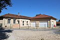
Multipurpose hall

Public place
Library
school

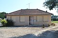
Mairie ´Sulignat
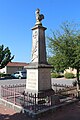
War memorial

Water tower


Web links
Commons : Sulignat - collection of images, videos and audio files