Chaleins
| Chaleins | ||
|---|---|---|

|
|
|
| region | Auvergne-Rhône-Alpes | |
| Department | Ain | |
| Arrondissement | Bourg-en-Bresse | |
| Canton | Villars-les-Dombes | |
| Community association | Val de Saone Center | |
| Coordinates | 46 ° 2 ′ N , 4 ° 48 ′ E | |
| height | 193-267 m | |
| surface | 17 km 2 | |
| Residents | 1,342 (January 1, 2017) | |
| Population density | 79 inhabitants / km 2 | |
| Post Code | 01480 | |
| INSEE code | 01075 | |
| Website | www.mairie-chaleins.fr | |
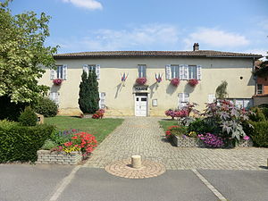
 Town hall ( Mairie ) of Chaleins |
||
Chaleins is a French commune with 1,342 inhabitants (as of January 1 2017) in the Ain department in the region of Auvergne Rhône-Alpes . It belongs to the arrondissement of Bourg-en-Bresse and the canton of Villars-les-Dombes (until 2015: canton of Saint-Trivier-sur-Moignans ).
geography
Chaleins is located about 30 kilometers north of Lyon on the western edge of the Dombes landscape, rich in lakes . Chaleins is surrounded by the neighboring communities of Lurcy in the north and north-west, Francheleins in the north and north-east, Villeneuve in the east, Ars-sur-Formans in the south and south-east, Frans in the south and south-west, Fareins in the west and Messimy-sur-Saône in the west and Northwest.
Population development
| year | 1962 | 1968 | 1975 | 1982 | 1990 | 1999 | 2006 | 2013 |
| Residents | 485 | 461 | 428 | 594 | 754 | 1,025 | 1,181 | 1,199 |
| Source: Cassini and INSEE | ||||||||
Attractions
- Saint-Julien church
Community partnerships
There is a partnership with the Italian municipality of Villar Pellice in the province of Turin (Piémont).

