
Bressolles (Ain)
| Bressolles | ||
|---|---|---|
.svg)
|
|
|
| region | Auvergne-Rhône-Alpes | |
| Department | Ain | |
| Arrondissement | Bourg-en-Bresse | |
| Canton | Meximieux | |
| Community association | Côtière à Montluel | |
| Coordinates | 45 ° 52 ' N , 5 ° 6' E | |
| height | 205-292 m | |
| surface | 7.93 km 2 | |
| Residents | 911 (January 1, 2017) | |
| Population density | 115 inhabitants / km 2 | |
| Post Code | 01360 | |
| INSEE code | 01062 | |
 Mairie Bressolles |
||

Bressolles is a French commune in the Ain department in the region of Auvergne Rhône-Alpes . It belongs to the canton of Meximieux in the Belley arrondissement . It borders on Pizay in the north-west, Faramans in the north, Bourg-Saint-Christophe in the north-east, Béligneux in the east, Balan in the south and Dagneux in the south-west . The inhabitants call themselves Bressollands or Bressollandes.
Population development
| year | 1962 | 1968 | 1975 | 1982 | 1990 | 1999 | 2008 | 2014 |
|---|---|---|---|---|---|---|---|---|
| Residents | 226 | 252 | 270 | 446 | 480 | 590 | 717 | 826 |
Attractions
- Saint-Marcellin church
- Military cemetery
- War memorial
- Public heating powered by solar power, called "Four" in French
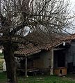
- Former farm

Saint-Marcellin church
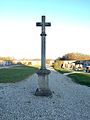
Military cemetery with a hall cross
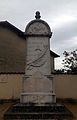
War memorial

Public heating on the main street
"Four de France" heating station

Water tower

Former farm
.JPG)
_(3).JPG)
.JPG)


_-_gros_plan.jpg)
.JPG)
Web links
Commons : Bressolles - collection of images, videos and audio files