Beaupont
| Beaupont | ||
|---|---|---|
|
|
||
| region | Auvergne-Rhône-Alpes | |
| Department | Ain | |
| Arrondissement | Bourg-en-Bresse | |
| Canton | Saint-Etienne-du-Bois | |
| Community association | Bassin de Bourg-en-Bresse | |
| Coordinates | 46 ° 25 ' N , 5 ° 16' E | |
| height | 187-228 m | |
| surface | 14.07 km 2 | |
| Residents | 689 (January 1, 2017) | |
| Population density | 49 inhabitants / km 2 | |
| Post Code | 01270 | |
| INSEE code | 01029 | |
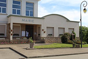
 Mairie Beaupont |
||
Beaupont is a French municipality with 689 inhabitants (at January 1, 2017) in the Ain department in the region of Auvergne Rhône-Alpes ; it belongs to the canton of Saint-Étienne-du-Bois in the Bourg-en-Bresse arrondissement .
geography
The municipality of Beaupont is located in the Bresse , about 20 kilometers north of Bourg-en-Bresse . The Solnan flows through the municipality, which borders the Saône-et-Loire department in the north . The A 39 runs between Kernort and Solnan .
Neighboring municipalities of Beaupont are Varennes-Saint-Sauveur in the north, Condal in the northeast, Domsure in the east, Pirajoux in the south and Cormoz in the northwest.
Population development
| year | 1962 | 1968 | 1975 | 1982 | 1990 | 1999 | 2006 | 2015 |
| Residents | 678 | 575 | 515 | 415 | 422 | 492 | 553 | 682 |
Attractions
- Ferme de Bevay ( Monument historique )
- Saint-Antoine church
Personalities
- The European politician Robert Schuman (1886–1963) fled to the Saint-Joseph orphanage during World War II
- Roger Pingeon (1940-2017), Tour de France winner 1967, lived in Beaupont
Web links
Commons : Beaupont - collection of images, videos and audio files


