
Sainte-Olive
| Sainte-Olive | ||
|---|---|---|
.svg)
|
|
|
| region | Auvergne-Rhône-Alpes | |
| Department | Ain | |
| Arrondissement | Bourg-en-Bresse | |
| Canton | Villars-les-Dombes | |
| Community association | Dombes | |
| Coordinates | 46 ° 1 ′ N , 4 ° 56 ′ E | |
| height | 281-301 m | |
| surface | 7.39 km 2 | |
| Residents | 283 (January 1, 2017) | |
| Population density | 38 inhabitants / km 2 | |
| Post Code | 01330 | |
| INSEE code | 01382 | |
.JPG) Mairie Sainte-Olive |
||

Sainte-Olive is a French commune in the Ain department in the region of Auvergne Rhône-Alpes . It belongs to the canton of Villars-les-Dombes in the Bourg-en-Bresse arrondissement . It is located in an area with many small lakes and borders in the north on Saint-Trivier-sur-Moignans , in the east on Bouligneux , in the south-east on Lapeyrouse , in the south-west on Ambérieux-en-Dombes and in the west on Villeneuve .
Population development
| year | 1962 | 1968 | 1975 | 1982 | 1990 | 1999 | 2008 | 2014 |
|---|---|---|---|---|---|---|---|---|
| Residents | 135 | 110 | 115 | 157 | 196 | 253 | 310 | 291 |
Attractions
- Saint-Allyre church
- War memorial
- Military cemetery

Saint-Allyre church

War memorial
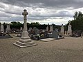
Military cemetery
.JPG)
.JPG)
.JPG)
Web links
Commons : Sainte-Olive - Collection of images, videos and audio files