
Genouilleux
| Genouilleux | ||
|---|---|---|
|
||
| region | Auvergne-Rhône-Alpes | |
| Department | Ain | |
| Arrondissement | Bourg-en-Bresse | |
| Canton | Châtillon-sur-Chalaronne | |
| Community association | Val de Saone Center | |
| Coordinates | 46 ° 7 ' N , 4 ° 47' E | |
| height | 169-231 m | |
| surface | 4.1 km 2 | |
| Residents | 612 (January 1, 2017) | |
| Population density | 149 inhabitants / km 2 | |
| Post Code | 01090 | |
| INSEE code | 01169 | |
 Mairie and school |
||

Genouilleux is a French commune in the Ain department in the region of Auvergne Rhône-Alpes . It belongs to the canton of Châtillon-sur-Chalaronne in the Bourg-en-Bresse arrondissement .
geography
The former Route nationale 433 leads via Genouilleux. The municipality borders on Dracé (point of contact) to the northwest , Peyzieux-sur-Saône to the north and east , Guéreins to the south and Taponas to the west . The Saône forms the border with taponas.
Population development
| year | 1962 | 1968 | 1975 | 1982 | 1990 | 1999 | 2008 | 2014 |
|---|---|---|---|---|---|---|---|---|
| Residents | 259 | 220 | 204 | 253 | 320 | 399 | 581 | 583 |
Attractions
- Tour de Chavagneux, Monument historique
- Military cemetery
- War memorial
- Saint-Pierre-et-Saint-Paul church

Tour de Chavagneux

Military cemetery

War memorial
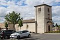
Saint-Pierre-et-Saint-Paul church


Web links
Commons : Genouilleux - collection of images, videos and audio files