
Villeneuve (Ain)
| Villeneuve | ||
|---|---|---|

|
|
|
| region | Auvergne-Rhône-Alpes | |
| Department | Ain | |
| Arrondissement | Bourg-en-Bresse | |
| Canton | Villars-les-Dombes | |
| Community association | Dombes Saône Vallée | |
| Coordinates | 46 ° 1 ′ N , 4 ° 50 ′ E | |
| height | 230-287 m | |
| surface | 26.79 km 2 | |
| Residents | 1,501 (January 1, 2017) | |
| Population density | 56 inhabitants / km 2 | |
| Post Code | 01480 | |
| INSEE code | 01446 | |
| Website | www.villeneuve01.fr | |
_-340.jpg) Municipal administration and post office in Villeneuve |
||

Villeneuve is a French commune with 1,501 inhabitants (at January 1, 2017) in the department of Ain in the region Auvergne Rhône-Alpes . It belongs to the canton of Villars-les-Dombes in the arrondissement of Bourg-en-Bresse and is a member of the Dombes Saône Vallée municipal association .
geography
location
Villeneuve is located at 268 m , about 36 km southwest of the prefecture of Bourg-en-Bresse , 29 km north of Lyon and 31 km south of the city of Mâcon (as the crow flies). The village lies on the edge of the landscape with many lakes and the historical province of Dombes in the southwest of the Ain department. Villeneuve's neighboring municipalities are Francheleins and Saint-Trivier-sur-Moignans in the north, Sainte-Olive (point of contact) and Ambérieux-en-Dombes in the east, Savigneux and Ars-sur-Formans in the south, and Chaleins in the west.
topography
The area of the community area of 26.79 km 2 comprises a section of the western Dombes, a high plateau crossed by countless lakes and bodies of water between the Saône valley in the west and the Jura in the east. With altitudes between 260 m and 280 m , the majority of the municipality is almost flat, only in the northwest does a slight decline in terrain caused by the Le Mâtre stream , which drains the municipality towards the Saône. This part and the immediate vicinity of the village are used intensively for agriculture, while the strings of lakes and ponds (French: étang ) that are typical of the Dombes begin on the north and east . The proportion of fields (64%), meadows (8%) and other agricultural areas (15%) is correspondingly high. The lakes and the forest in between make up about 5% each.
Community structure
In addition to the actual town center, Villeneuve also includes several hamlet settlements and farms, including the larger ones:
- Ouroux ( 245 m ) and Agnereins ( 261 m ) north of the town center,
- Chanteins ( 277 m ) in the east,
- Les Améries ( 270 m ), settlement in the southern part of the village.
history
The various hamlets of Villeneuve all go back to formerly independent small mansions and parishes . In the High Middle Ages already Agnereins (passed in pago Lugdunensi in agro Animiacense , 954) and Ouroux ( in Comitatu Lugdunensi: hoc est æcclesiam in honore Sancti Martini, in villa quam Oratorios vacant , 969). Their spellings developed over Ainninens (1176), A (g) ninens (approx. 1250), A (i) gnynens (1325), Aignineins (1492) and Agnerens (1662) or de Oratorio (1156) and O (u ) rours (1299) to the current spellings. A few centuries later, Villeneuve ( Villanova , approx. 1250) and Chanteins ( Chantens , 1289) were first mentioned in a document; the spelling of the latter developed from Chante (y) nz (1299-1369), Chanteins (1587), Chantin (1662 ) and Champteins (1789).
In the Middle Ages, Villeneuve formed a small fortified dominion under the sovereignty of the Lords of Thoire-Villars, whose possessions included the other hamlets of today's Villeneuve. At the beginning of the 14th century, the Lords of Beaujeu gained influence over Villeneuve and other parts of the western Dombes, from 1406 it came under the sovereignty of the Bourbons for several centuries , to whom the rule of Beaujeu had been bequeathed and Villeneuve became the capital of a castlane ( French: châtellenie ) made.
The administrative structure created in the course of the French Revolution assigned Ouroux and Chanteins to the municipality of Villeneuve, the incorporation of Agnereins happened in 1827. After Villeneuve belonged to the canton of Saint-Trivier-sur-Moignans from 1793 to 2015 , it became part after the nationwide reorganization of the cantons of the canton of Villars-les-Dombes .
_-_7.JPG)
During the Second World War and in response to the Allied landings in Normandy , the Gestapo carried out a series of shootings of members of the Resistance around Lyon in June 1944 . On June 13, 1944, 19 prisoners from Montluc prison were brought to Villeneuve to an area on the roadside of what is now the D936 near Agnereins and executed. There is a memorial there today.
Attractions
A permanent house in the north of the municipality (French: Maison-forte de Villon ), which is classified as a monument historique , dates from the 14th century and thus from the time of the medieval mansions . It was the seat of the Villion family, mentioned in 1150, and was conquered by the Savoy in 1378. In the 15th and 16th centuries, when different families from Villeneuve and Fareins changed hands , major changes were made to the brick building.
The village church of Sainte Madeleine de Villeneuve was built in 1832 to replace a previous building that had become too small after the incorporation of Agnereins and Chanteins. Stones from the old church and the demolished Agnereins chapel were reused.
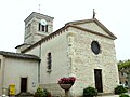
The village church of Sainte-Madeleine

The Maison-forte de Villon

Gate of the Maison-forte de Villon

The pond at the Maison-forte de Villon
_-339.jpg)


population
| Population development | |
|---|---|
| year | Residents |
| 1962 | 746 |
| 1968 | 689 |
| 1975 | 630 |
| 1982 | 733 |
| 1990 | 845 |
| 1999 | 939 |
| 2006 | 1,259 |
| 2011 | 1,396 |
With 1501 inhabitants (as of January 1, 2017) Villeneuve is one of the smaller communities in the Ain department. After the village had grown rapidly in the 19th century to around 1100 inhabitants, the number of inhabitants decreased continuously in the 20th century. It was only in the last few decades that the population began to increase again, surpassing the heyday of the 19th century. The local residents of Villeneuve are called Villeneuvois (es) in French .
Economy and Infrastructure
_-_boucherie_ferm%C3%A9e.JPG)
To this day, Villeneuve is mainly characterized by agriculture , in particular animal production and field management . In addition, there are now various local small businesses. In the meantime the village has also developed into a residential community. Many people in employment are commuters who work in the larger towns of the Ain, but also in the greater Lyon area.
The village is on the main D936 road that connects Bourg-en-Bresse with Villefranche-sur-Saône . Other side streets lead in a star shape to the neighboring communities. The next motorway connection to the A6 is around 11 km south of Villefranche. To the east of the village the route of the high-speed line LGV Sud-Est cuts through the municipality, the nearest train stations are in Mâcon-Loché TGV and Lyon Part-Dieu and Lyon-Saint-Exupéry TGV . The airport in the region is Lyon-St-Exupéry (47 km).
education
In Villeneuve there is a state école primaire (elementary school with an integrated preschool ).
Personalities
- René Leynaud (1910-1944); Journalist, poet and member of the Combat , executed in Villeneuve.
- Jean Gouailhardou (1911-1944); Member of the Resistance, executed in Villeneuve in 1944.
Web links
Individual evidence
- ↑ 2006 data from CORINE Land Cover , available e.g. B. at www.statistiques.developpement-durable.gouv.fr ( Memento of the original from March 24, 2016 in the Internet Archive ) Info: The archive link has been inserted automatically and has not yet been checked. Please check the original and archive link according to the instructions and then remove this notice. .
- ↑ a b É. Philipon: Dictionnaire Topographique du Département de l'Ain . Imprimerie Nationale, 1911, p. 3, 92, 466, 467 (French, online [PDF; accessed January 4, 2014]).
- ↑ a b Villeneuve - notice communale. In: cassini.ehess.fr. Retrieved on August 26, 2015 (French, INSEE population from 1968 ).
- ^ Tombes des 28 patriotes fusillés à Saint-Didier-de-Formans. In: Musée de la résistance en ligne. Retrieved November 22, 2015 (French).
- ^ Maison-forte de Villon in the Base Mérimée of the French Ministry of Culture (French).
- ↑ French Statistics Institute ( www.insee.fr )
- ↑ Commune de Villeneuve - Dossier complet. In: INSEE . Retrieved August 26, 2015 (French).