Monthieux
| Monthieux | ||
|---|---|---|
|
|
||
| region | Auvergne-Rhône-Alpes | |
| Department | Ain | |
| Arrondissement | Bourg-en-Bresse | |
| Canton | Villars-les-Dombes | |
| Community association | Dombes | |
| Coordinates | 45 ° 57 ' N , 4 ° 56' E | |
| height | 281-311 m | |
| surface | 10.75 km 2 | |
| Residents | 646 (January 1, 2017) | |
| Population density | 60 inhabitants / km 2 | |
| Post Code | 01390 | |
| INSEE code | 01261 | |
Monthieux is a French municipality with 646 inhabitants (as of January 1 2017) in the department of Ain in the region Auvergne Rhône-Alpes . It belongs to the canton of Villars-les-Dombes in the Bourg-en-Bresse arrondissement . The inhabitants are called Birotans .
geography
Monthieux is located in the middle of the lake landscape of the Dombes , about 35 kilometers southwest of the prefecture of Bourg-en-Bresse . Monthieux is surrounded by the neighboring municipalities of Ambérieux-en-Dombes in the north and northwest, Lapeyrouse in the north and northeast, Saint-Marcel in the east, Saint-André-de-Corcy in the south, Civrieux in the southwest and Saint-Jean-de-Thurigneux in the West.
Population development
| year | 1962 | 1968 | 1975 | 1982 | 1990 | 1999 | 2006 | 2013 |
| Residents | 192 | 194 | 217 | 247 | 344 | 578 | 591 | 669 |
| Source: Cassini and INSEE | ||||||||
Attractions
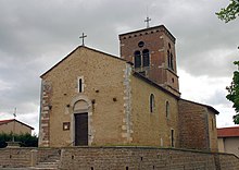
- Saint-Pierre Church ( Monument historique )
- Le Breuil-de-Monthieux castle
Web links
Commons : Monthieux - collection of images, videos and audio files

