
Neyron
| Neyron | ||
|---|---|---|
|
||
| region | Auvergne-Rhône-Alpes | |
| Department | Ain | |
| Arrondissement | Bourg-en-Bresse | |
| Canton | Miribel | |
| Community association | Miribel et Le Plateau | |
| Coordinates | 45 ° 49 ′ N , 4 ° 56 ′ E | |
| height | 165-312 m | |
| surface | 5.36 km 2 | |
| Residents | 2,527 (January 1, 2017) | |
| Population density | 471 inhabitants / km 2 | |
| Post Code | 01700 | |
| INSEE code | 01275 | |
| Website | http://www.neyron.fr/ | |
 Neyron Town Hall |
||

Neyron is a French commune with a population of 2,527 (as at 1st January 2017) in the department of Ain in the region Auvergne Rhône-Alpes . It belongs to the Arrondissement of Bourg-en-Bresse , the canton of Miribel and the municipality of Miribel et Le Plateau . The inhabitants are called Neyrolands .
geography
Neyron is located about 9 kilometers northwest of Lyon on the Canal de Miribel . Neyron is surrounded by the neighboring communities of Miribel in the north and east, Vaulx-en-Velin in the south and Rillieux-la-Pape in the west and north-west.
The autobahn triangle of the Autoroutes A42 and A46 is located in the municipality . The station is on the Lyon – Genève railway line .
Population development
| year | 1962 | 1968 | 1975 | 1982 | 1990 | 1999 | 2006 | 2012 |
| Residents | 951 | 1,032 | 1,138 | 1,326 | 1,723 | 2.157 | 2,278 | 2,506 |
Attractions
- Romanesque church Saint-Didier from the 10th century, largely restored in the 19th century
- Sermenaz Castle and Tower
- Semenaz military installation, battery built between 1878 and 1879
- Town hall, built in 1874/1875

Saint Didier Church

Sermenaz Tower
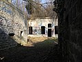
Battery Sermenaz
.JPG)


Web links
Commons : Neyron - collection of images, videos and audio files