Autoroute A 46
| Autoroute A46 in France | ||||||||||||||||||||||||||||||||||||||||||||||||||||||||||||||||||||||

|
||||||||||||||||||||||||||||||||||||||||||||||||||||||||||||||||||||||
| |
||||||||||||||||||||||||||||||||||||||||||||||||||||||||||||||||||||||
| map | ||||||||||||||||||||||||||||||||||||||||||||||||||||||||||||||||||||||
| Basic data | ||||||||||||||||||||||||||||||||||||||||||||||||||||||||||||||||||||||
| Operator: | APRR | |||||||||||||||||||||||||||||||||||||||||||||||||||||||||||||||||||||
| further operator: | ASF | |||||||||||||||||||||||||||||||||||||||||||||||||||||||||||||||||||||
| Overall length: | 62 km | |||||||||||||||||||||||||||||||||||||||||||||||||||||||||||||||||||||
|
Regions : |
||||||||||||||||||||||||||||||||||||||||||||||||||||||||||||||||||||||
| The A 46 at the Venissieux exit | ||||||||||||||||||||||||||||||||||||||||||||||||||||||||||||||||||||||
|
Course of the road
|
||||||||||||||||||||||||||||||||||||||||||||||||||||||||||||||||||||||
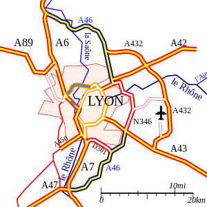
The Autoroute A 46 is a French motorway that was created to relieve the urban area of Lyon and to connect the A 6 , A 7 , A 42 and A 43 motorways that end there .
course
The A 46 runs east of the city of Lyon . It consists of three parts and is toll-free throughout :
- The northern part, also known as "A 46N", begins shortly after the end of the toll area of the A 6 at the Péage de Villefranche-Limas , and ends after about 27 kilometers at the junction with the A 42 in a flyover to the N 346 . This part of the A 46, like the A 6, is financed and serviced by the APRR motorway company .
- The middle part begins at the junction with the A 42 and ends after about 14 kilometers at the junction with the A 43. This middle part is officially not a motorway, but a French national road (as N 346), and is financed by public funds. In order to avoid confusion with the ongoing traffic, this section is signposted like a motorway (white lettering on a blue background), not in the colors customary in France for national roads (black lettering on a white background).
- The southern part, also known as "A 47S", begins at the junction with the A 43 and ends after about 21 kilometers just before the start of the toll area of the A 7 at the Péage de Vienne-Reventin . This part of the A 46, like the A 7, is financed and serviced by the ASF motorway company.
The total length of the A 46 is 62 kilometers and is financed in roughly equal parts by the motorway operating companies APRR and ASF and the French state. The length of the route with the actual motorway character is 47 km in total.
history
The A 6 and A 7 motorways built in the 1960s and 1970s connect the north of France, Germany and the Benelux countries with the south of France and Spain , and run in a very confusing route through the center of Lyon. The north-south traffic prevailing here, especially during the holiday season, is additionally increased by the rush hour between Écully and the Villeurbanne in the north and St. Etienne in the south, and led to high environmental pollution and long traffic jams, especially in front of the bottleneck of the two-lane Tunnel de Fourvière . To relieve the urban area of through traffic while simultaneously connecting the A 42 and A 43 motorways as well as the connection to the Lyon-Bron and Lyon-Saint-Exupéry airports , the Villeurbanne and the Eurexpo exhibition center , the A 46 was developed as a joint project between the motorway operating companies APRR and ASF and the public sector built.
- ?. ? 1988: Opening of Neyron - Rillieux-la-Pape (A 42 - RD1084)
- ?. ? 1990: Opening of Rillieux-la-Pape - Vancia (RD1084 - FP)
- ?. ? 1990: Opening Vancia - Les Echets (FP - Exit 3), (1st lane)
- ?. ? 199 ?: Opening Vancia - Les Echets (FP - Exit 3), (2nd lane)
- November 1, 1991: Opening of Les Echets - Anse (exit 3 - A 6)
- ?. ? 1991 (?): Opening of Manissieux - Brosses (A 43 - exit 12)
- ?. ? 1992: Opening of Mions - Ternay (exit 14 - A 47)
- ?. ? 1992: Opening for through traffic between A 6 and A 7
- April 10, 1993: Opening of Brosses - Mions (Departures 12-14)
- ?. ? 1994: opening of the descent de Corbas (exit 14)
- ?. ? 2007: Extension to 2 × 3 lanes between Grenay and Mionnay
Big cities on the highway
Web links
- Autoroute A 46 in German and French version of the SARATLAS
- Autoroute A 46 on WikiSara (French)


