
Salavre
| Salavre | ||
|---|---|---|
|
||
| region | Auvergne-Rhône-Alpes | |
| Department | Ain | |
| Arrondissement | Bourg-en-Bresse | |
| Canton | Saint-Etienne-du-Bois | |
| Community association | Bassin de Bourg-en-Bresse | |
| Coordinates | 46 ° 22 ′ N , 5 ° 21 ′ E | |
| height | 203-561 m | |
| surface | 7.8 km 2 | |
| Residents | 272 (January 1, 2017) | |
| Population density | 35 inhabitants / km 2 | |
| Post Code | 01270 | |
| INSEE code | 01391 | |
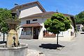
 Salavre with the Saint-Rémi church |
||

Salavre is a French commune in the Ain department in the region of Auvergne Rhône-Alpes . It belongs to the canton of Saint-Étienne-du-Bois in the Bourg-en-Bresse arrondissement .
geography
The municipality borders on Coligny to the north, Val d'Épy to the northeast, Bourcia to the east, Courmangoux to the southeast, Verjon to the south and Villemotier to the southwest and west .
In addition to the main settlement, Salavre also includes the hamlet of Dingier at 450 meters above sea level.
Population development
| year | 1962 | 1968 | 1975 | 1982 | 1990 | 1999 | 2008 | 2014 |
|---|---|---|---|---|---|---|---|---|
| Residents | 343 | 288 | 238 | 218 | 246 | 285 | 282 | 293 |
Attractions
- Calvaire de Dingier , Monument historique
- Saint-Rémi church
- fountain
- Lavoir
- War memorial

Calvaire de Dingier

fountain

Lavoir
Mairie Salavre

War memorial


Web links
Commons : Salavre - collection of images, videos and audio files