
Châtenay (Ain)
| Châtenay | ||
|---|---|---|
|
||
| region | Auvergne-Rhône-Alpes | |
| Department | Ain | |
| Arrondissement | Bourg-en-Bresse | |
| Canton | Ceyzériat | |
| Community association | Dombes | |
| Coordinates | 46 ° 2 ' N , 5 ° 12' E | |
| height | 272-317 m | |
| surface | 14.95 km 2 | |
| Residents | 341 (January 1, 2017) | |
| Population density | 23 inhabitants / km 2 | |
| Post Code | 01320 | |
| INSEE code | 01090 | |

Châtenay is a French commune in the Ain department in the region of Auvergne Rhône-Alpes . It borders Dompierre-sur-Veyle to the north, Villette-sur-Ain to the east, Chalamont to the south and west and Saint-Nizier-le-Désert to the northwest .
history
The settlement already existed in the 9th century.
Population development
| year | 1962 | 1968 | 1975 | 1982 | 1990 | 1999 | 2008 | 2014 |
|---|---|---|---|---|---|---|---|---|
| Residents | 252 | 249 | 225 | 266 | 276 | 308 | 337 | 332 |
Attractions
- Saint-Pierre church
- Memorial stone and plaque
- Former fortress, built in the 18th century
- Biard and Montchamp castles
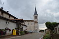
Saint-Pierre church

Mairie Châtenay

Memorial stone and plaque


.JPG)
Web links
Commons : Châtenay - collection of images, videos and audio files