Dagneux
| Dagneux | ||
|---|---|---|

|
|
|
| region | Auvergne-Rhône-Alpes | |
| Department | Ain | |
| Arrondissement | Bourg-en-Bresse | |
| Canton | Meximieux | |
| Community association | Côtière à Montluel | |
| Coordinates | 45 ° 51 ' N , 5 ° 4' E | |
| height | 189-285 m | |
| surface | 6.65 km 2 | |
| Residents | 4,717 (January 1, 2017) | |
| Population density | 709 inhabitants / km 2 | |
| Post Code | 01120 | |
| INSEE code | 01142 | |
| Website | www.ville-dagneux.fr | |
Dagneux is a French commune with 4717 inhabitants (as of January 1, 2017) in the Ain department in the Auvergne-Rhône-Alpes region .
geography
The community is located a few kilometers north of the banks of the Rhone , in the catchment area of the city of Lyon, 20 kilometers away . Dagneux forms a coherent settlement pattern with the neighboring municipality of Montluel .
history
The place was first mentioned in 885 under the name Dagnacum . For a long time the village belonged to the municipality of Montluel. The commune became independent on December 31, 1829 by a decree of the French King Charles X.
Population development
| year | 1962 | 1968 | 1975 | 1982 | 1990 | 1999 | 2006 |
| Residents | 1,150 | 1,372 | 1,812 | 2,091 | 3,317 | 3,757 | 3,906 |
Military cemetery
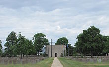
In the vicinity of the village is the German war cemetery Dagneux , which is looked after by the Volksbund Deutsche Kriegsgräberfürsorge Saxony-Anhalt and is looked after by young people. Almost 20,000 German soldiers are buried there, mainly victims of the fighting in southern France after the Allies landed on the Côte d'Azur on August 15, 1944 ( Operation Dragoon ).
The German soldiers who died in captivity around Dagneux are also buried here.

