Montrevel-en-Bresse
| Montrevel-en-Bresse | ||
|---|---|---|

|
|
|
| region | Auvergne-Rhône-Alpes | |
| Department | Ain | |
| Arrondissement | Bourg-en-Bresse | |
| Canton | Attignat | |
| Community association | Bassin de Bourg-en-Bresse | |
| Coordinates | 46 ° 20 ' N , 5 ° 8' E | |
| height | 192-220 m | |
| surface | 10.27 km 2 | |
| Residents | 2,489 (January 1, 2017) | |
| Population density | 242 inhabitants / km 2 | |
| Post Code | 01340 | |
| INSEE code | 01266 | |
Montrevel-en-Bresse is a French commune with 2,489 inhabitants (at January 1, 2017) in the department of Ain in the region Auvergne Rhône-Alpes ; it belongs to the arrondissement of Bourg-en-Bresse , is the capital of the canton of Attignat . Pierre de La Baume († 1544) and Pierre Chanel († 1841) were born in Montrevel.
geography
Montrevel is located in the Bresse on the Reyssouze , a left tributary of the Saône , 18 kilometers northwest of Bourg-en-Bresse and about 25 kilometers east of Mâcon .
Neighboring municipalities of Montrevel-en-Bresse are Jayat in the north, Malafretaz in the east, Saint-Martin-le-Châtel in the south, Saint-Didier-d'Aussiat in the southwest and Marsonnas in the west.
Population development
| year | 1962 | 1968 | 1975 | 1982 | 1990 | 1999 | 2007 | 2016 |
| Residents | 1,388 | 1,495 | 1,653 | 2,000 | 1,973 | 1.994 | 2,311 | 2,463 |
Attractions
- Manoir de la Charme, a manor house
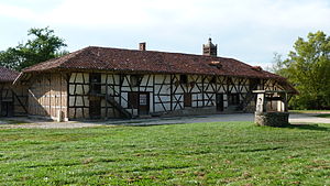
- Ferme de Sougey, a Bressehaus
See also: List of Monuments historiques in Montrevel-en-Bresse
Individual evidence
- ^ Entry in the Base Mérimée of the Ministry of Culture. Retrieved January 4, 2012 (French).
- ^ Entry in the Base Mérimée of the Ministry of Culture. Retrieved January 4, 2012 (French).
Web links
- Montrevel-en-Bresse (French)


