
Châtillon-la-Palud
| Châtillon-la-Palud | ||
|---|---|---|
.svg)
|
|
|
| region | Auvergne-Rhône-Alpes | |
| Department | Ain | |
| Arrondissement | Bourg-en-Bresse | |
| Canton | Ceyzériat | |
| Community association | Dombes | |
| Coordinates | 45 ° 59 ′ N , 5 ° 15 ′ E | |
| height | 218-326 m | |
| surface | 14.01 km 2 | |
| Residents | 1,584 (January 1, 2017) | |
| Population density | 113 inhabitants / km 2 | |
| Post Code | 01320 | |
| INSEE code | 01092 | |
 The municipal administration ( mairie ) of Châtillon-la-Palud |
||

Châtillon-la-Palud is a French commune with 1,584 inhabitants (as of January 1 2017) in the department of Ain in the region Auvergne Rhône-Alpes . It belongs to the canton of Ceyzériat (until 2015: canton of Chalamont ) in the arrondissement of Bourg-en-Bresse . The inhabitants are called Chatillonais .
geography
Châtillon-la-Palud is located about 25 kilometers south of Bourg-en-Bresse in the historic province of Bresse am Ain . Neighboring municipalities of Châtillon-la-Palud are Villette-sur-Ain in the north, Saint-Maurice-de-Rémens in the east and south-east, Villieu-Loyes-Mollon in the south, Crans in the west and south-west and Chalamont in the west and north-west.
Population development
| year | 1962 | 1968 | 1975 | 1982 | 1990 | 1999 | 2006 | 2013 |
| Residents | 582 | 660 | 574 | 814 | 874 | 1,074 | 1,395 | 1,573 |
| Source: Cassini and INSEE | ||||||||
Attractions
- Saint-Irénée church, a historic monument since 1966
- Saint-Georges church in Bublanne
- Remains of the 13th century castle of La Palud
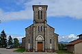
Saint-Irénée church

Saint-Georges church


Parish partnership
A partnership has existed with the German municipality of Deisenhausen in Swabia (Bavaria) since 1988.
Personalities
- Louis de La Palud (1370 / 1380–1451), cardinal, bishop of Lausanne (1431–1433), Avignon (1433–1441) and Saint-Jean-de-Maurienne (1441–1451)