
Saint-André-le-Bouchoux
| Saint-André-le-Bouchoux | ||
|---|---|---|
|
||
| region | Auvergne-Rhône-Alpes | |
| Department | Ain | |
| Arrondissement | Bourg-en-Bresse | |
| Canton | Châtillon-sur-Chalaronne | |
| Community association | Dombes | |
| Coordinates | 46 ° 7 ' N , 5 ° 5' E | |
| height | 259-274 m | |
| surface | 9.32 km 2 | |
| Residents | 390 (January 1, 2017) | |
| Population density | 42 inhabitants / km 2 | |
| Post Code | 01240 | |
| INSEE code | 01335 | |
 Mairie Saint-André-le-Bouchoux |
||

Saint-André-le-Bouchoux is a French commune in the Ain department in the region of Auvergne Rhône-Alpes . It belongs to the canton of Châtillon-sur-Chalaronne in the Bourg-en-Bresse arrondissement . It is bordered by Condeissiat to the north, Saint-André-sur-Vieux-Jonc to the north-east, Saint-Paul-de-Varax to the east, Saint-Germain-sur-Renon to the south, and Saint-Georges-sur to the southwest -Renon and to the west at Romans .
Population development
| year | 1962 | 1968 | 1975 | 1982 | 1990 | 1999 | 2008 | 2014 |
|---|---|---|---|---|---|---|---|---|
| Residents | 163 | 142 | 127 | 156 | 171 | 191 | 307 | 368 |
Attractions
- Saint-André church, monument historique
- War memorial
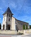
Saint-André church
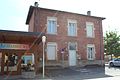
former mairie

War memorial


Web links
Commons : Saint-André-le-Bouchoux - Collection of images, videos and audio files