Ain (river)
| Ain | ||
|
Overview map |
||
| Data | ||
| Water code | FR : V2-0200 | |
| location | France , regions of Bourgogne-Franche-Comté and Auvergne-Rhône-Alpes | |
| River system | Rhône | |
| Drain over | Rhône → Mediterranean | |
| source | on the municipal boundary of Conte and Nozeroy 46 ° 44 ′ 58 ″ N , 6 ° 1 ′ 23 ″ E |
|
| Source height | approx. 680 m | |
| muzzle | in the municipality of Saint-Maurice-de-Gourdans in the Rhône Coordinates: 45 ° 47 '43 " N , 5 ° 10' 37" E 45 ° 47 '43 " N , 5 ° 10' 37" E |
|
| Mouth height | approx. 185 m | |
| Height difference | approx. 495 m | |
| Bottom slope | approx. 2.6 ‰ | |
| length | 190 km | |
| Catchment area | 3765 km² | |
| Discharge at the gauge Chazey-sur-Ain A Eo : 3630 km² |
MQ Mq |
120 m³ / s 33.1 l / (s km²) |
| Left tributaries | see adjacent table | |
| Right tributaries | see adjacent table | |
| Reservoirs flowed through | Lac de Vouglans , Lac de Coiselet | |
| Small towns | Champagnole | |
|
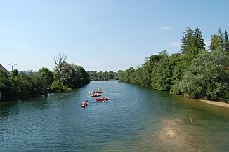
The Ain at Pont-du-Navoy |
||
The Ain is a river in France that runs in the Bourgogne-Franche-Comté and Auvergne-Rhône-Alpes regions and flows into the Rhone . It crosses the departments of Jura and Ain , for which he also acts as a namesake.
geography
Source de l'Ain
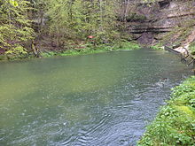
The Source de l'Ain (Eng. Quelle des Ain ) is a mighty karst spring from the karst rock of the French Jura . The source pot is located in a narrow, wooded valley on the municipal boundary of Conte and Nozeroy , at an altitude of about 680 m. It can pour up to 60,000 l / s , but it can also dry up completely. If, after heavy rain or snowmelt comes to the maximum fill, the observation deck at the source is often completely under water. The large cave portal at the bottom of the Source de l'Ain can only be accessed up to 35 m when the spring is absolutely dry. Depending on the water level, the color of the spring water also changes. After the source has dried up, the first water-bearing tributary of the Ain is the approximately 11 km long serpentine that flows into the valley from the northeast about one kilometer below the Source de l'Ain.
course
The Ain flows essentially in a south-southwest direction, takes on numerous streams and rivers, cutting deep into the Jura. At Syam it is abruptly directed to the northwest and after Champagnole it reaches a high valley about 20 kilometers long in its original direction of flow, through which it runs in mighty meanders . Southwest of Poncin , the Ain leaves its gorge in order to reach the Rhône in hilly terrain , into which it joins as a right tributary after a total of 190 kilometers in the municipality of Saint-Maurice-de-Gourdans (approx. 40 km above Lyon ).
Tributaries
(Order in flow direction)
| Surname | Length in km | Mouth side |
|---|---|---|
| Serpentine | 11 | right |
| Saine | 19th | Left |
| Angillon | 27 | right |
| Hérisson | 21st | Left |
| Drouvenant | 18th | Left |
| Cimante | 11 | Left |
| Bienne | 69 | Left |
| Oignin | 44 | Left |
| Valouse | 42 | right |
| Riez | 13 | Left |
| Oiselon | 14th | Left |
| Suran | 74 | right |
| Cozance | 12 | Left |
| Albarine | 59 | Left |
| Toison | 15th | right |
Places on the river
- Sirod
- Syam
- Champagnole
- Crotenay
- Pont-de-Poitte
- Moirans-en-Montagne
- Thoirette
- Poncin
- Neuville-sur-Ain
- Pont d'Ain
- Priay
- Châtillon-la-Palud
- Chazey-sur-Ain
- Saint-Jean-de-Niost
- Saint-Maurice-de-Gourdans
Hydrology
The Ain reaches a maximum gradient of 12 to 18 per mille on its way into the valley. During its course it is dammed 15 times in reservoirs to generate energy, e.g. B. in Lac de Coiselet and in Lac de Vouglans . In addition to generating electricity, the Lac de Vouglans is also used to curb heavy water events that tend to occur in spring and autumn.
Picture gallery
A TGV duplex on the Cize-Bolozon viaduct above the Ain
See also
Web links
Individual evidence
- ↑ Source geoportail.gouv.fr
- ↑ estuary geoportail.gouv.fr
- ↑ a b c The information on the length of the river is based on the information about the Ain at SANDRE (French), accessed on January 17, 2012, rounded to the nearest kilometer.
- ↑ hydro.eaufrance.fr (station: V2942010 , option: Synthèse )


